IMAGES TAKEN NEAR TO
Green Lane, KEITH, AB55 6NX
Introduction
This page details the photographs taken nearby to Green Lane, AB55 6NX by members of the Geograph project.
The Geograph project started in 2005 with the aim of publishing, organising and preserving representative images for every square kilometre of Great Britain, Ireland and the Isle of Man.

There are currently over 7.5m images from over14,400 individuals and you can help contribute to the project by visiting https://www.geograph.org.uk
Image Map
Images are licensed for reuse under creativecommons.org/licenses/by-sa/2.0
Notes
- Clicking on the map will re-center to the selected point.
- The higher the marker number, the further away the image location is from the centre of the postcode.
Image Listing (44 Images Found)
Images are licensed for reuse under creativecommons.org/licenses/by-sa/2.0
Image
Details
Distance
1
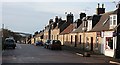
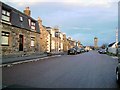
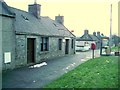
Main Street, Newmill
The street is lined with traditional stone houses typical of planned villages such as Newmill.
Image: © Anne Burgess
Taken: 19 Jan 2007
0.04 miles
10
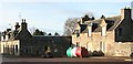
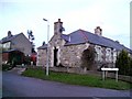
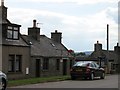
Newmill Square
The houses in this north-western corner of the square are empty and boarded up. At least they provide a suitable spot for recycling facilities.
Image: © Anne Burgess
Taken: 19 Jan 2007
0.08 miles