IMAGES TAKEN NEAR TO
Crossroads, KEITH, AB55 6NL
Introduction
This page details the photographs taken nearby to AB55 6NL by members of the Geograph project.
The Geograph project started in 2005 with the aim of publishing, organising and preserving representative images for every square kilometre of Great Britain, Ireland and the Isle of Man.

There are currently over 7.5m images from over14,400 individuals and you can help contribute to the project by visiting https://www.geograph.org.uk
Image Map
Images are licensed for reuse under creativecommons.org/licenses/by-sa/2.0
Notes
- Clicking on the map will re-center to the selected point.
- The higher the marker number, the further away the image location is from the centre of the postcode.
Image Listing (8 Images Found)
Images are licensed for reuse under creativecommons.org/licenses/by-sa/2.0
Image
Details
Distance
1
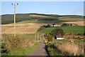
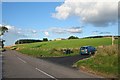
The lane running eastwards from Myreside.
The lane meets the B9018, Keith/Cullen road.
Image: © Des Colhoun
Taken: 12 Sep 2006
0.09 miles
2
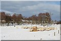
Bossy Hillocks
A flock of sheep clusters round fodder in a field by the B9018. The modern house which has replaced an older one at Bossy Hillocks can be glimpsed through the trees at left.
Image: © Anne Burgess
Taken: 11 Feb 2009
0.10 miles
3
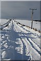
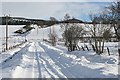
Power Lines
Beneath a series of power lines, the snow-covered road to Myreside reminds us of the conditions commonly faced by our forebears who farmed these areas when winters were much harsher.
Image: © Anne Burgess
Taken: 11 Feb 2009
0.13 miles
4
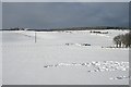
Wester Windyhills and Myreside
Wester Windyhills is on the left, and Myreside to the right. The trees at right are a corner of the scrubby woodland at Bossy Hillocks, and the foreground snow has been trampled by a flock of wintering sheep.
Image: © Anne Burgess
Taken: 11 Feb 2009
0.15 miles
5
Nethertown Farm on the brow of the hill.
Image: © Des Colhoun
Taken: 12 Sep 2006
0.15 miles
6
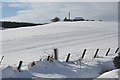
Nethertown Farm
Not to be confused with umpteen other Nethertons and Nethertowns all over the country, this one is in the parish of Grange, and older maps name it Nethertown of Windyhills.
Image: © Anne Burgess
Taken: 11 Feb 2009
0.21 miles
7
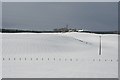
Wester Windyhills
The farm stands on a hill above the glen. The swathe of virgin snow cover below it is a reminder of what winters were like for the former occupants of such hill farms.
Image: © Anne Burgess
Taken: 11 Feb 2009
0.24 miles
8
Wester Windyhills
As the wind began to rise, it became evident how appropriate the name of this exposed farm is.
Image: © Anne Burgess
Taken: 11 Feb 2009
0.24 miles