IMAGES TAKEN NEAR TO
Gallowhill Terrace, KEITH, AB55 6LW
Introduction
This page details the photographs taken nearby to Gallowhill Terrace, AB55 6LW by members of the Geograph project.
The Geograph project started in 2005 with the aim of publishing, organising and preserving representative images for every square kilometre of Great Britain, Ireland and the Isle of Man.

There are currently over 7.5m images from over14,400 individuals and you can help contribute to the project by visiting https://www.geograph.org.uk
Image Map
Images are licensed for reuse under creativecommons.org/licenses/by-sa/2.0
Notes
- Clicking on the map will re-center to the selected point.
- The higher the marker number, the further away the image location is from the centre of the postcode.
Image Listing (6 Images Found)
Images are licensed for reuse under creativecommons.org/licenses/by-sa/2.0
Image
Details
Distance
1
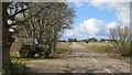
Grange Crossroads
The B9018 Cullen to Keith road.
Image: © Richard Webb
Taken: 17 Apr 2015
0.08 miles
2
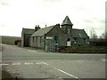
Crossroads Primary School
The school is still open and is situated at Crossroads on the Keith to Cullen road.
Image: © Christopher Gillan
Taken: 12 Apr 2006
0.10 miles
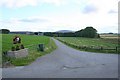
4
Bogs of Paithnick
This is the entrance to Bogs of Paithnick.
Image: © Anne Burgess
Taken: 1 Oct 2022
0.10 miles
5
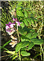
Bush Vetch (Vicia sepium)
A few late flowers on the roadside verge.
Image: © Anne Burgess
Taken: 1 Oct 2022
0.16 miles
6

Corn Sow-thistle (Sonchus arvensis)
These showy flowers, also known as Perennial Sow-thistle, line the roadside here in late summer and early autumn.
Image: © Anne Burgess
Taken: 1 Oct 2022
0.24 miles