IMAGES TAKEN NEAR TO
Crossroads, KEITH, AB55 6LU
Introduction
This page details the photographs taken nearby to AB55 6LU by members of the Geograph project.
The Geograph project started in 2005 with the aim of publishing, organising and preserving representative images for every square kilometre of Great Britain, Ireland and the Isle of Man.

There are currently over 7.5m images from over14,400 individuals and you can help contribute to the project by visiting https://www.geograph.org.uk
Image Map
Images are licensed for reuse under creativecommons.org/licenses/by-sa/2.0
Notes
- Clicking on the map will re-center to the selected point.
- The higher the marker number, the further away the image location is from the centre of the postcode.
Image Listing (2 Images Found)
Images are licensed for reuse under creativecommons.org/licenses/by-sa/2.0
Image
Details
Distance
1
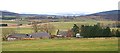
Greenbog
Evidently there is no need now for a steading the size of this, as the buildings on the left are becoming ruinous. The farm commands a fine view over Strath Isla towards the Hill of Foundland in the distance.
Image: © Anne Burgess
Taken: 19 Jan 2007
0.09 miles
2
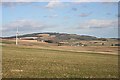
Near Starhill
Looking towards distant Lurg Hill, with Balnamoon in the middle distance.
Image: © Anne Burgess
Taken: 2 Mar 2009
0.22 miles