IMAGES TAKEN NEAR TO
Crossroads, KEITH, AB55 6LQ
Introduction
This page details the photographs taken nearby to AB55 6LQ by members of the Geograph project.
The Geograph project started in 2005 with the aim of publishing, organising and preserving representative images for every square kilometre of Great Britain, Ireland and the Isle of Man.

There are currently over 7.5m images from over14,400 individuals and you can help contribute to the project by visiting https://www.geograph.org.uk
Image Map
Images are licensed for reuse under creativecommons.org/licenses/by-sa/2.0
Notes
- Clicking on the map will re-center to the selected point.
- The higher the marker number, the further away the image location is from the centre of the postcode.
Image Listing (5 Images Found)
Images are licensed for reuse under creativecommons.org/licenses/by-sa/2.0
Image
Details
Distance
1
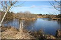
New Pond
This isn't on the map yet, and it looks artificial. In spite of being partly frozen it was receiving the attentions of several regrettably rather camera-shy mallards.
Image: © Anne Burgess
Taken: 6 Mar 2009
0.11 miles
2
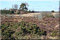
Foggy Moss
This is just a small part of several acres of boggy ground. This Foggy Moss is in the parish of Grange, and not to be confused with Foggie Moss above Newmill, which is in the parish of Keith and only about 3 kilometres away as the crow flies. The house on the high ground beyond is one of several new ones which have been built along this minor road.
Image: © Anne Burgess
Taken: 6 Mar 2009
0.16 miles
3
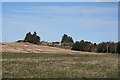
Chapelhead
Chapelhead stands on rising ground above Foggy Moss.
Image: © Anne Burgess
Taken: 6 Mar 2009
0.18 miles
4
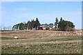
Newtack
Surrounded by the traditional sheltering trees, Newtack stands close above the Burn of Aultmore.
Image: © Anne Burgess
Taken: 6 Mar 2009
0.21 miles
5
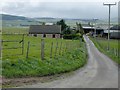
Newtack Farm near Keith
Road leading to Newtack Farm. The farm produces high quality Aberdeen Angus beef.
Image: © Christopher Gillan
Taken: 29 May 2006
0.24 miles