IMAGES TAKEN NEAR TO
Grange, KEITH, AB55 6LL
Introduction
This page details the photographs taken nearby to AB55 6LL by members of the Geograph project.
The Geograph project started in 2005 with the aim of publishing, organising and preserving representative images for every square kilometre of Great Britain, Ireland and the Isle of Man.

There are currently over 7.5m images from over14,400 individuals and you can help contribute to the project by visiting https://www.geograph.org.uk
Image Map
Images are licensed for reuse under creativecommons.org/licenses/by-sa/2.0
Notes
- Clicking on the map will re-center to the selected point.
- The higher the marker number, the further away the image location is from the centre of the postcode.
Image Listing (2 Images Found)
Images are licensed for reuse under creativecommons.org/licenses/by-sa/2.0
Image
Details
Distance
1
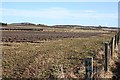
Near Auchinhove.
Ploughed land beside the farm buildings at Auchinhove. Knock Hill, the most prominent landmark for miles around, is visible on the distant skyline at left. Just to the right of it, a clump of trees markes Holladyke, and the large farm to the right is Clerkseat, which is on the gridline at the far side of the square.
Image: © Anne Burgess
Taken: 6 Mar 2009
0.14 miles
2
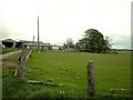
Clerkseat Farm near A95.
Clerkseat Farm close to the A95 Keith to Banff road.
Image: © Christopher Gillan
Taken: 29 May 2006
0.19 miles