IMAGES TAKEN NEAR TO
KEITH, AB55 6LE
Introduction
This page details the photographs taken nearby to AB55 6LE by members of the Geograph project.
The Geograph project started in 2005 with the aim of publishing, organising and preserving representative images for every square kilometre of Great Britain, Ireland and the Isle of Man.

There are currently over 7.5m images from over14,400 individuals and you can help contribute to the project by visiting https://www.geograph.org.uk
Image Map
Images are licensed for reuse under creativecommons.org/licenses/by-sa/2.0
Notes
- Clicking on the map will re-center to the selected point.
- The higher the marker number, the further away the image location is from the centre of the postcode.
Image Listing (2 Images Found)
Images are licensed for reuse under creativecommons.org/licenses/by-sa/2.0
Image
Details
Distance
1

River Isla at Bridge of Montgrew
Looking downstream; it looks as if part of the bank has recently subsided into the river. Meikle Balloch is the hill on the skyline.
Image: © Anne Burgess
Taken: 13 Feb 2009
0.24 miles
2
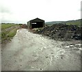
Shed close to A95 Keith to Banff main road.
It looks derelict but the tyre tracks indicate that it is still in use.
Image: © Christopher Gillan
Taken: 29 May 2006
0.25 miles