IMAGES TAKEN NEAR TO
KEITH, AB55 6LB
Introduction
This page details the photographs taken nearby to AB55 6LB by members of the Geograph project.
The Geograph project started in 2005 with the aim of publishing, organising and preserving representative images for every square kilometre of Great Britain, Ireland and the Isle of Man.

There are currently over 7.5m images from over14,400 individuals and you can help contribute to the project by visiting https://www.geograph.org.uk
Image Map
Images are licensed for reuse under creativecommons.org/licenses/by-sa/2.0
Notes
- Clicking on the map will re-center to the selected point.
- The higher the marker number, the further away the image location is from the centre of the postcode.
Image Listing (9 Images Found)
Images are licensed for reuse under creativecommons.org/licenses/by-sa/2.0
Image
Details
Distance
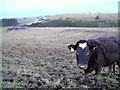
1
Crossburn
The farm takes its name from the adjacent Cross Burn, which flows into the River Isla in this grid square.
Image: © Anne Burgess
Taken: 19 Jan 2007
0.01 miles
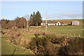
2
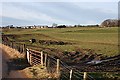
Crossburn
The farm buildings at Crossburn stand in a relatively sheltered spot, but still above the boggy haugh land.
Image: © Anne Burgess
Taken: 13 Feb 2009
0.02 miles
3
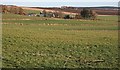
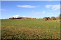
Crossburn
Farmland east of Newmill. The farm in the distance is Brae of Montgrew.
Image: © Anne Burgess
Taken: 17 Jan 2007
0.02 miles
4
View North from the B9017 near Crossburn
Image: © Alan hodgson
Taken: 15 Nov 2018
0.14 miles
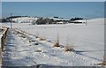
6
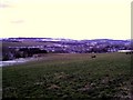
Crossburn
Fields beside the Cross Burn. On the skyline is the village of Newmill.
Image: © Anne Burgess
Taken: 19 Jan 2007
0.18 miles
7
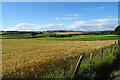
Field of Barley
In the distance there is a glimpse of part of Keith.
Image: © Anne Burgess
Taken: 19 Aug 2022
0.19 miles
8
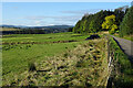
Near Newmill
Newmill village is hidden by the trees on the right. There's a glimpse of Keith among the trees further away.
Image: © Anne Burgess
Taken: 8 Oct 2020
0.23 miles