IMAGES TAKEN NEAR TO
KEITH, AB55 5QD
Introduction
This page details the photographs taken nearby to AB55 5QD by members of the Geograph project.
The Geograph project started in 2005 with the aim of publishing, organising and preserving representative images for every square kilometre of Great Britain, Ireland and the Isle of Man.

There are currently over 7.5m images from over14,400 individuals and you can help contribute to the project by visiting https://www.geograph.org.uk
Image Map
Images are licensed for reuse under creativecommons.org/licenses/by-sa/2.0
Notes
- Clicking on the map will re-center to the selected point.
- The higher the marker number, the further away the image location is from the centre of the postcode.
Image Listing (17 Images Found)
Images are licensed for reuse under creativecommons.org/licenses/by-sa/2.0
Image
Details
Distance
1
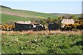
Wester Chalder
Seen from the road. This is one of a handful of surviving farms and crofts in Strath Isla.
Image: © Anne Burgess
Taken: 27 Apr 2007
0.01 miles
2
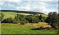
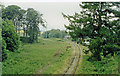
Near Wester Chalder
The attractive farmland of the River Isla valley, viewed from the Keith & Dufftown Railway.
Image: © Mary and Angus Hogg
Taken: 20 Aug 2011
0.02 miles
3
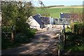
Mill Cottage
Mill Cottage and Wester Chalder share this gateway from the public road.
Image: © Anne Burgess
Taken: 27 Apr 2007
0.02 miles
4
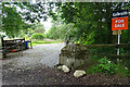
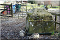
Gatepost at Wester Chalder
Fors some reason, perhaps because I have normally been driving rather than walking, I had not previously noticed the pair of truncated stone pyramids that stand at the entrance to Wester Chalder.
Image: © Anne Burgess
Taken: 21 Jul 2020
0.04 miles
5
Gatepost at Wester Chalder
Not surprisingly, it hasn't changed since Image] was taken. On this occasion, however, I looked for its twin and it wasn't there. So did I imagine the second one, or has it been removed?
Image: © Anne Burgess
Taken: 12 Mar 2021
0.04 miles
6
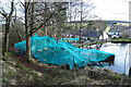
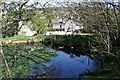
Netting on a Duckpond
We were intrigued by the netting, and on enquiry we learned that the pond had been netted over in an effort to prevent the ducks succumbing to avian flu, of which there is currently an outbreak in the area.
Image: © Anne Burgess
Taken: 12 Mar 2021
0.04 miles
7
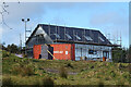
New House
Another new house has appeared since I last passed this way.
Image: © Anne Burgess
Taken: 12 Mar 2021
0.18 miles
8
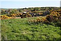
Goldenknowes
Another farm which has fallen into ruin.
Image: © Anne Burgess
Taken: 27 Apr 2007
0.19 miles
9
Goldenknowes
The remains of the farmhouse of Goldenknowes.
Image: © Anne Burgess
Taken: 27 Apr 2007
0.20 miles
10
Auchindachy station (remains), 1997
View northwards, towards Keith etc.: ex-GNSR (Aberdeen) - Keith - Craigellachie - Elgin/Boat of Garten line. The station was closed when the regular passenger service ceased on 6/5/68, but although closed for goods in 11/71 the line survived to convey Excursions to - and whisky from, Dufftown at least until 1/91. The track remaining here in 1997 was saved and the Keith & Dufftown Heritage Railway reintroduced trains over it to Drummuir in 6/2000 and on to Keith on 18/8/01,'reopening' Auchindachy station.
Image: © Ben Brooksbank
Taken: 3 Jul 1997
0.21 miles