IMAGES TAKEN NEAR TO
Botriphnie, KEITH, AB55 5PQ
Introduction
This page details the photographs taken nearby to AB55 5PQ by members of the Geograph project.
The Geograph project started in 2005 with the aim of publishing, organising and preserving representative images for every square kilometre of Great Britain, Ireland and the Isle of Man.

There are currently over 7.5m images from over14,400 individuals and you can help contribute to the project by visiting https://www.geograph.org.uk
Image Map
Images are licensed for reuse under creativecommons.org/licenses/by-sa/2.0
Notes
- Clicking on the map will re-center to the selected point.
- The higher the marker number, the further away the image location is from the centre of the postcode.
Image Listing (4 Images Found)
Images are licensed for reuse under creativecommons.org/licenses/by-sa/2.0
Image
Details
Distance
1
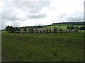
Felled woodland at Bogallie
The wood was called Broomhill Wood. There is a nice circle of trees left round the edge, though they hardly obscure the debris inside.
Image: © David Purchase
Taken: 15 Jun 2019
0.06 miles
2
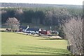
Broomhill Cottage
My thanks to Terry Pavlis for telling me the name of this cottage, which wasn't named on the maps available to me when I uploaded the image. The forest immediately beside it is Broomhill Wood.
Image: © Anne Burgess
Taken: 3 Apr 2009
0.16 miles
3
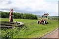
Bogallie
Farm machinery waiting its turn to be used again, with the house at Parkhead in the background.
Image: © Anne Burgess
Taken: 28 Jun 2007
0.19 miles
4
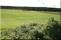
Bogallie
Looking uphill towards the remains of a croft in a clump of broadleaved trees beside the rows of conifers in Bellyhack Wood. The field contains a cereal crop.
Image: © Anne Burgess
Taken: 28 Jun 2007
0.21 miles