IMAGES TAKEN NEAR TO
KEITH, AB55 5PB
Introduction
This page details the photographs taken nearby to AB55 5PB by members of the Geograph project.
The Geograph project started in 2005 with the aim of publishing, organising and preserving representative images for every square kilometre of Great Britain, Ireland and the Isle of Man.

There are currently over 7.5m images from over14,400 individuals and you can help contribute to the project by visiting https://www.geograph.org.uk
Image Map
Images are licensed for reuse under creativecommons.org/licenses/by-sa/2.0
Notes
- Clicking on the map will re-center to the selected point.
- The higher the marker number, the further away the image location is from the centre of the postcode.
Image Listing (10 Images Found)
Images are licensed for reuse under creativecommons.org/licenses/by-sa/2.0
Image
Details
Distance
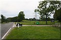
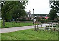
1
A bend in the A96
Heading south east towards Huntly.
Image: © JThomas
Taken: 20 Jul 2014
0.09 miles
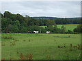
4
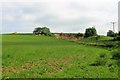
Disused Quarry
A disused quarry by Birkenburn seen over farmland.
Image: © Andrew Wood
Taken: 3 Jun 2018
0.19 miles
5
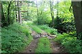
Not the biggest Ford
A small tributary of the Tarnash Burn crossing a farm track.
Image: © Andrew Wood
Taken: 3 Jun 2018
0.19 miles
6
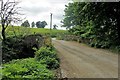
Bridge of Tarnash
A small road bridge over the Tarnash Burn.
Image: © Andrew Wood
Taken: 3 Jun 2018
0.20 miles
7
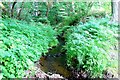
Birken Burn
The Birken Burn flowing toward the camera and the Tarnash Burn.
Image: © Andrew Wood
Taken: 3 Jun 2018
0.21 miles
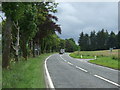
9
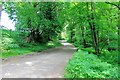
Birkenburn Road
The access road to Birkenburn Farm.
Image: © Andrew Wood
Taken: 3 Jun 2018
0.23 miles