IMAGES TAKEN NEAR TO
KEITH, AB55 5NY
Introduction
This page details the photographs taken nearby to AB55 5NY by members of the Geograph project.
The Geograph project started in 2005 with the aim of publishing, organising and preserving representative images for every square kilometre of Great Britain, Ireland and the Isle of Man.

There are currently over 7.5m images from over14,400 individuals and you can help contribute to the project by visiting https://www.geograph.org.uk
Image Map
Images are licensed for reuse under creativecommons.org/licenses/by-sa/2.0
Notes
- Clicking on the map will re-center to the selected point.
- The higher the marker number, the further away the image location is from the centre of the postcode.
Image Listing (4 Images Found)
Images are licensed for reuse under creativecommons.org/licenses/by-sa/2.0
Image
Details
Distance
1
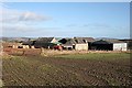
Gibston
One of many farms now largely abandoned; though the barns are still in use the house is boarded up.
Image: © Anne Burgess
Taken: 25 Feb 2009
0.05 miles
2
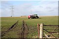
Spreading Muck
While I was wandering around in this area, this farmer made several trips up to this field at Gibston with cargoes of muck.
Image: © Anne Burgess
Taken: 25 Feb 2009
0.10 miles
3
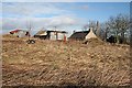
Corrugated Iron
Rusting corrugated iron and collapsing sheds. Not even the 1872 six-inch map shows a name for this farm.
Image: © Anne Burgess
Taken: 25 Feb 2009
0.18 miles
4
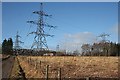
Electricity Transformer Station
This installation occupies the site of Greens of Achorties.
Image: © Anne Burgess
Taken: 25 Feb 2009
0.22 miles