IMAGES TAKEN NEAR TO
Drummuir, KEITH, AB55 5JE
Introduction
This page details the photographs taken nearby to AB55 5JE by members of the Geograph project.
The Geograph project started in 2005 with the aim of publishing, organising and preserving representative images for every square kilometre of Great Britain, Ireland and the Isle of Man.

There are currently over 7.5m images from over14,400 individuals and you can help contribute to the project by visiting https://www.geograph.org.uk
Image Map
Images are licensed for reuse under creativecommons.org/licenses/by-sa/2.0
Notes
- Clicking on the map will re-center to the selected point.
- The higher the marker number, the further away the image location is from the centre of the postcode.
Image Listing (20 Images Found)
Images are licensed for reuse under creativecommons.org/licenses/by-sa/2.0
Image
Details
Distance
1
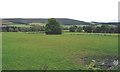
Easterton
Farmland above Strath Isla near Drummuir Castle.
Image: © Anne Burgess
Taken: 31 May 2005
0.03 miles
2
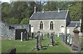
Botriphnie Parish Kirk
The kirk was designed by George Angus and built in 1816-1820 close to an earlier kirk dating from 1617. The tracery in the windows was added by R B Pratt during alterations in 1901. The dedication was to St Fumac, who had a preaching outpost here in the 8th or 9th century, and whose well, with healing properties, is nearby. On the left are the remains of the 1617 kirk, now used as a mausoleum of the Stuart family.
Image: © Anne Burgess
Taken: 14 May 1984
0.03 miles
3
Parish Kirk of Botriphnie, Drummuir
Described on the notice board as "Church of Scotland welcomes you to Kirk of Keith: St Rufus, Botriphnie and Grange".
I am grateful to Anne Burgess for the following additional information:
"I know that the board says 'Kirk of Keith: St Rufus Botriphnie and Grange', but that is only because the parishes of Botriphnie and Grange are now a united charge with Keith. This kirk is the Parish Kirk of Botriphnie.
The Kirk of Keith is St Rufus: see Image and Image For the Kirk of Grange, see Image"
Image: © David Purchase
Taken: 15 Jun 2019
0.21 miles
4
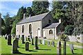
Botriphnie Parish Kirk
The parish kirk at Botriphnie once a separate parish it is now linked with Keith and Grange even the village name has changed to Drummuir.
Image: © Andrew Wood
Taken: 16 Aug 2020
0.21 miles
5
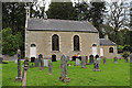
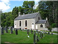
Botriphnie Parish Kirk
The kirk was designed by George Angus and built in 1816-1820 close to an earlier kirk dating from 1617. The tracery in the windows was added by R B Pratt during alterations in 1901. The dedication was to St Fumac, who had a preaching outpost here in the 8th or 9th century. See https://canmore.org.uk/site/16846/botriphnie-old-parish-church for more details.
Image: © Anne Burgess
Taken: 24 Aug 2019
0.21 miles
6
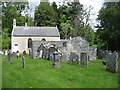
Parish Kirk of Botriphnie, Drummuir
With the remains of an older kirk in the foreground.
For some additional information, see Image
Image: © David Purchase
Taken: 15 Jun 2019
0.21 miles
7
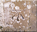
OS Cut Mark - Drummuir and Botriphnie Parish Church
Botriphnie Parish Church. Not on legacy OS database, but appears on the 1975 map on the south face, east angle of church, with a height of 163.17m.
Image: © thejackrustles
Taken: 8 Feb 2015
0.21 miles
8
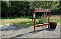
Drummuir Station
The middle station on the Keith & Dufftown Railway. After being closed by BR in 1991, the K&DR Association reopened the line from Dufftown as far as Drummuir in 2000. It now continues to Keith Town.
Image: © Mary and Angus Hogg
Taken: 20 Aug 2011
0.22 miles
9
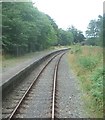
Drummuir railway station, Banffshire
Opened in 1862 by the Great North of Scotland Railway on its line from Keith Junction to Craigellachie, this station closed to passengers in 1968. View south west from the cab. It is now part of the Keith & Dufftown heritage railway.
Image: © Nigel Thompson
Taken: 29 Aug 2008
0.22 miles
10
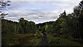
Drummuir Station on the Keith and Dufftown Railway
Image: © Peter Moore
Taken: 13 Oct 2015
0.22 miles