IMAGES TAKEN NEAR TO
KEITH, AB55 5JA
Introduction
This page details the photographs taken nearby to AB55 5JA by members of the Geograph project.
The Geograph project started in 2005 with the aim of publishing, organising and preserving representative images for every square kilometre of Great Britain, Ireland and the Isle of Man.

There are currently over 7.5m images from over14,400 individuals and you can help contribute to the project by visiting https://www.geograph.org.uk
Image Map
Images are licensed for reuse under creativecommons.org/licenses/by-sa/2.0
Notes
- Clicking on the map will re-center to the selected point.
- The higher the marker number, the further away the image location is from the centre of the postcode.
Image Listing (4 Images Found)
Images are licensed for reuse under creativecommons.org/licenses/by-sa/2.0
Image
Details
Distance
1
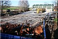
LH Stainless Process Engineering
The name on the building doesn't reveal a lot, but the company makes equipment for food and drink processing, especially distilling. The company web site is at http://www.l-h-s.co.uk/index.php. The stripes on the ground are the long shadows of trees on the boundary of the firm's premises.
Image: © Anne Burgess
Taken: 3 Apr 2009
0.08 miles
2
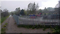
Engineering company yard at Towiemore
Viewed from the Keith and Dufftown Railway.
Image: © John Lucas
Taken: 3 May 2019
0.08 miles
3
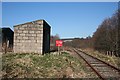
Keith to Dufftown Railway Line
Looking towards Keith from the former halt at Towiemore. I am surprised that in this day and age of rampant, if not over-zealous, Health and Safety legislation, a red warning sign at an unprotected level crossing is regarded as sufficient to prevent anyone wandering on to the line.
Image: © Anne Burgess
Taken: 3 Apr 2009
0.10 miles
4
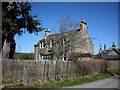
Towiemore House, near Drummuir
Large House in a Hamlet near Drummuir.
Image: © Christopher Gillan
Taken: 30 Apr 2006
0.12 miles