IMAGES TAKEN NEAR TO
Nelson Court, KEITH, AB55 5FT
Introduction
This page details the photographs taken nearby to Nelson Court, AB55 5FT by members of the Geograph project.
The Geograph project started in 2005 with the aim of publishing, organising and preserving representative images for every square kilometre of Great Britain, Ireland and the Isle of Man.

There are currently over 7.5m images from over14,400 individuals and you can help contribute to the project by visiting https://www.geograph.org.uk
Image Map
Images are licensed for reuse under creativecommons.org/licenses/by-sa/2.0
Notes
- Clicking on the map will re-center to the selected point.
- The higher the marker number, the further away the image location is from the centre of the postcode.
Image Listing (18 Images Found)
Images are licensed for reuse under creativecommons.org/licenses/by-sa/2.0
Image
Details
Distance
1
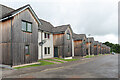
Nelson Brae
The row of identical houses even has matching 'gardens' and window frames. The wooden cladding is looking a bit grey where not sheltered from the weather.
Image: © Anne Burgess
Taken: 15 Jul 2022
0.08 miles
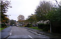
2
The Pastures
A largish housing development. In spite of the sign saying 'Bungalows Released' it is still protected by Health and Safety notices and No Entry signs.
Image: © Anne Burgess
Taken: 13 Feb 2009
0.09 miles
3
A Multiplicity of Nelsons
Why do they do this? It would be much so more sensible to use a different name for each street, rather than the same name with a different suffix. At least it's not as bad as Baberton Mains in Edinburgh.
Image: © Anne Burgess
Taken: 13 Feb 2009
0.09 miles
5
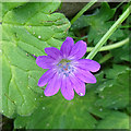
Hedgerow Cranesbill (Geranium pyrenaicum)
One of several species of Cranesbill that occur in this area.
Image: © Anne Burgess
Taken: 21 Jul 2020
0.12 miles
6
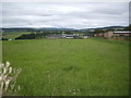
Corsairtly Farm, Keith
Seen from the track along the west side of Keith Showground.
Image: © Stanley Howe
Taken: 27 Aug 2013
0.13 miles
7
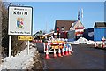
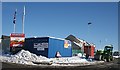
Welcome to Keith
Roadworks and traffic lights greeted everyone arriving at Keith on the B9014 today. 'The Pastures' is a building site, soon to be more housing.
Image: © Anne Burgess
Taken: 13 Feb 2009
0.14 miles
8
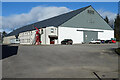
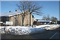
W N Lindsay
W N Lindsay specialises in grain storage. In 2020 the family-run company sold its Keith operation to Simpson's Malt, another family-run company. See https://www.wnlindsay.com/ and https://www.grampianonline.co.uk/news/new-owner-announced-for-keith-grain-merchant-218257/.
Image: © Anne Burgess
Taken: 12 Mar 2021
0.15 miles
9
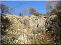
Cuthill Quarry
The abandoned Cuthill Quarry (formerly named Glenisla Quarry) beside Keith, exposing outcrops of the Cuthill Limestone Member.
Image: © Uamhair
Taken: 21 Feb 2021
0.17 miles
10
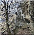
Cuthill Quarry
Banded Limestone in Cuthill (formerly Glenisla) Quarry.
Image: © Uamhair
Taken: 28 Feb 2021
0.18 miles