IMAGES TAKEN NEAR TO
Union Court, KEITH, AB55 5FG
Introduction
This page details the photographs taken nearby to Union Court, AB55 5FG by members of the Geograph project.
The Geograph project started in 2005 with the aim of publishing, organising and preserving representative images for every square kilometre of Great Britain, Ireland and the Isle of Man.

There are currently over 7.5m images from over14,400 individuals and you can help contribute to the project by visiting https://www.geograph.org.uk
Image Map
Images are licensed for reuse under creativecommons.org/licenses/by-sa/2.0
Notes
- Clicking on the map will re-center to the selected point.
- The higher the marker number, the further away the image location is from the centre of the postcode.
Image Listing (198 Images Found)
Images are licensed for reuse under creativecommons.org/licenses/by-sa/2.0
Image
Details
Distance
2
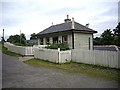
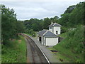
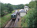
Keith Town station
Keith & Dufftown Railway. Access to platform by steps or by ramp.
Image: © Stanley Howe
Taken: 27 Aug 2013
0.03 miles
3
Keith station, Keith and Dufftown Railway
Off Church Lane. The main entrance is considerably higher than the platform requiring descent by steps within the building or via a gentle ramp to the right of the station. The station here is a 2003 a rebuild of the original Great North of Scotland Railway building dating from 1862.
Image: © John Lucas
Taken: 3 May 2019
0.03 miles
4
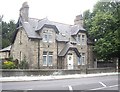
An elegant town house on Church Road, Keith
Opposite St Rufus Church.
Image: © Stanley Howe
Taken: 27 Aug 2013
0.03 miles
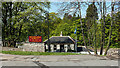
5
Keith Town Railway Station
Keith & Dufftown Heritage Railway.
Image: © JThomas
Taken: 20 Jul 2014
0.03 miles
6
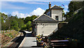
The rebuilt Keith Town station
The booking office and entrance stand at a higher level than the platform level waiting room. This is a rebuild of the original 1862 station which had been demolished, the new building having been opened in 2003. Difficult to say how close to the original is the new station, but it certainly has the atmosphere and 'feel' of an old building. A magnificent effort!
Image: © John Lucas
Taken: 3 May 2019
0.03 miles
7
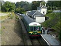
Keith Town Station
Looking down on the station from the road bridge. The station buildings are a recreation of the originals which were demolished after the line closed to passenger traffic.
Image: © Alan Murray-Rust
Taken: 22 Sep 2019
0.03 miles
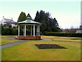
8
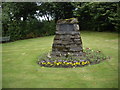
A cairn with brass plaque
On ground north of Church Road, just west of St Rufus Kirk. The plaque reads 'The Matthew Stewart Memorial Gardens; these and the adjacent gardens were laid out in 1958 for the use of the people of Keith'.
Image: © Stanley Howe
Taken: 27 Aug 2013
0.03 miles
9
Keith Town railway station, Banffshire
Opened in 1862 by the Great North of Scotland Railway on its line from Keith Junction to Craigellachie, this station closed to passengers in 1968. View north east. It is now open again as part of the Keith & Dufftown heritage railway.
Image: © Nigel Thompson
Taken: 29 Aug 2008
0.04 miles
10
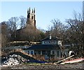
Keith Town Station
This is the Keith end of the preserved railway to Dufftown. The station building was brought from Kennethmont to replace the vanished original building. The tower of St Rufus, the parish kirk of Keith, rises above the station. Unfortunately the view is spoiled by the rubbish-strewn foreground.
Image: © Anne Burgess
Taken: 6 Feb 2008
0.04 miles