IMAGES TAKEN NEAR TO
Drum Road, KEITH, AB55 5ER
Introduction
This page details the photographs taken nearby to Drum Road, AB55 5ER by members of the Geograph project.
The Geograph project started in 2005 with the aim of publishing, organising and preserving representative images for every square kilometre of Great Britain, Ireland and the Isle of Man.

There are currently over 7.5m images from over14,400 individuals and you can help contribute to the project by visiting https://www.geograph.org.uk
Image Map
Images are licensed for reuse under creativecommons.org/licenses/by-sa/2.0
Notes
- Clicking on the map will re-center to the selected point.
- The higher the marker number, the further away the image location is from the centre of the postcode.
Image Listing (59 Images Found)
Images are licensed for reuse under creativecommons.org/licenses/by-sa/2.0
Image
Details
Distance

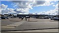
3
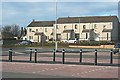
Westerton Road
Actually, this shows the rear of houses in Westerton Road, which now enjoy easy access to Tesco, and an open view across its car park.
Image: © Anne Burgess
Taken: 6 Mar 2009
0.09 miles
4
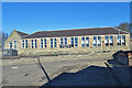
Stagestars
Stagestars Scotland School of Performing Arts https://www.stagestars-scotland.com/occupies the former Keith Primary School.
Image: © Anne Burgess
Taken: 26 Feb 2021
0.09 miles
5
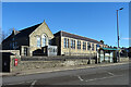
Former Primary School
The school building is now a performing arts college.
Image: © Anne Burgess
Taken: 26 Feb 2021
0.09 miles
7
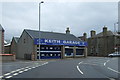
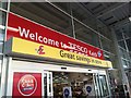
Tesco, Keith
Supermarket and car park.
Image: © Richard Webb
Taken: 17 Apr 2015
0.10 miles

9
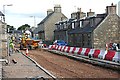
The Great Keith Roadworks
The A96 trunk road still runs through the town of Keith, and the powers that be have decided to carry out extensive road works on it, resulting in long queues of traffic at busy times. They have also blocked off the ends of most of the lanes which cross the street. One of the 'Road Closed' signs is visible at right. There are signs saying that no diversion is available, but local drivers know a myriad of rat-runs through the narrow streets, otherwise the congestion would be far longer.
Image: © Anne Burgess
Taken: 8 Sep 2008
0.11 miles
10
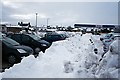
Snowbound Car Park
Tesco has done a fine job of clearing the parking spaces of snow. Wasn't it lucky there is a footpath available to dump the stuff on?
Image: © Anne Burgess
Taken: 11 Jan 2010
0.11 miles