IMAGES TAKEN NEAR TO
Land Street, KEITH, AB55 5DL
Introduction
This page details the photographs taken nearby to Land Street, AB55 5DL by members of the Geograph project.
The Geograph project started in 2005 with the aim of publishing, organising and preserving representative images for every square kilometre of Great Britain, Ireland and the Isle of Man.

There are currently over 7.5m images from over14,400 individuals and you can help contribute to the project by visiting https://www.geograph.org.uk
Image Map
Images are licensed for reuse under creativecommons.org/licenses/by-sa/2.0
Notes
- Clicking on the map will re-center to the selected point.
- The higher the marker number, the further away the image location is from the centre of the postcode.
Image Listing (189 Images Found)
Images are licensed for reuse under creativecommons.org/licenses/by-sa/2.0
Image
Details
Distance
1
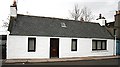
Cottage, Union Street
Union Street was originally called Cross Street, and it linked the Old Town with the New Town laid out from 1750 onwards at the instance of the Earl of Seafield. This is probably an 18th century cottage, though it would originally have been thatched, and the large window at the right-hand side is modern.
Image: © Anne Burgess
Taken: 16 Dec 2008
0.04 miles
3
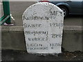
Old Mile Stone at Keith
The old mile stone is in Church Road Keith near the junction of A96 Aberdeen to Inverness and A95 Keith to Banff road.
Image: © Christopher Gillan
Taken: 7 Nov 2006
0.06 miles
4
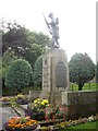
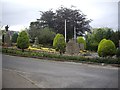
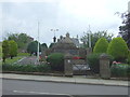
Regimental War Memorial, Keith
Commemorating those of the local battalion The Gordon Highlanders, who lost their lives in the two World Wars.
Image: © Stanley Howe
Taken: 27 Aug 2013
0.06 miles
5
Ordnance Survey Flush Bracket S7111
This can be found on the wall of the Police Station.
For more detail see : http://www.bench-marks.org.uk/bm20968
Image: © Peter Wood
Taken: 4 Oct 2012
0.07 miles
6
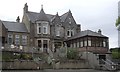
Ugie House Hotel, Keith
Off Church Road (A96).
Image: © Stanley Howe
Taken: 27 Aug 2013
0.07 miles
7
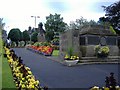
War Memorial gardens, Keith
At the north end of Land Street, near its junction with Church Street (A96).
Image: © Stanley Howe
Taken: 27 Aug 2013
0.07 miles
8
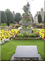
War Memorial gardens, Keith
This annex to the War Memorials is an inscribed tablet:
IN MEMORY OF THOSE
WHO DIED IN THE SERVICE
OF THEIR COUNTRY
OUTWITH THE PERIOD OF
THE TWO WORLD WARS
Image: © Stanley Howe
Taken: 27 Aug 2013
0.07 miles
10
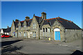
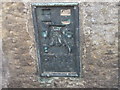
Police Station
The police station was designed by local architect Francis Davidson Robertson (1839-1922) and built in 1893.
Image: © Anne Burgess
Taken: 26 Feb 2021
0.07 miles