IMAGES TAKEN NEAR TO
Turner Court, KEITH, AB55 5DE
Introduction
This page details the photographs taken nearby to Turner Court, AB55 5DE by members of the Geograph project.
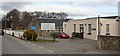
The Geograph project started in 2005 with the aim of publishing, organising and preserving representative images for every square kilometre of Great Britain, Ireland and the Isle of Man.

There are currently over 7.5m images from over14,400 individuals and you can help contribute to the project by visiting https://www.geograph.org.uk
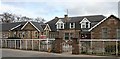
Image Map
Images are licensed for reuse under creativecommons.org/licenses/by-sa/2.0
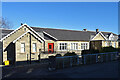
Notes
- Clicking on the map will re-center to the selected point.
- The higher the marker number, the further away the image location is from the centre of the postcode.
Image Listing (256 Images Found)
Images are licensed for reuse under creativecommons.org/licenses/by-sa/2.0
Image
Details
Distance
1
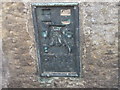
Ordnance Survey Flush Bracket S7111
This can be found on the wall of the Police Station.
For more detail see : http://www.bench-marks.org.uk/bm20968
Image: © Peter Wood
Taken: 4 Oct 2012
0.01 miles
2
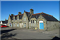
Police Station
The police station was designed by local architect Francis Davidson Robertson (1839-1922) and built in 1893.
Image: © Anne Burgess
Taken: 26 Feb 2021
0.02 miles
3
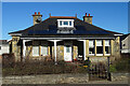
Allandale
A 20th century bungalow in Turner Street. I'm not sure that the solar panels, undoubtedly useful and beneficial to the occupants, enhance the appearance of the house.
Image: © Anne Burgess
Taken: 26 Feb 2021
0.03 miles
4
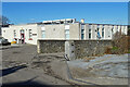
Keith Health Centre
This brutal concrete block is linked to the Turner Memorial Hospital, rather like 'a monstrous carbuncle on the face of a much-loved and elegant friend', to borrow a phrase from HRH the Duke of Rothesay.
Image: © Anne Burgess
Taken: 26 Feb 2021
0.06 miles
5
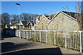
Turner Memorial Hospital
Keith still boasts a small general hospital. The beige concrete block in the foreground is the medical centre.
Image: © Anne Burgess
Taken: 6 Apr 2007
0.08 miles
6
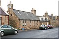
Land Street
The single-storey house nearest the camera is probably fairly typical of the original 18th century houses built along Land Street, though it would probably have been thatched, and would certainly not have had modern-style skylight windows. The dormers in the next cottage may also have been added when the thatch was replaced with slates. The third house has two storeys and pedimented dormer windows and is probably 19th century.
Image: © Anne Burgess
Taken: 16 Dec 2008
0.08 miles
7
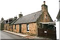
Union Street, formerly Cross Street
The nearest cottage is probably one of the original cottages built on this street which links Old Keith, down the hill to the left, with New Keith, founded in 1750 by the Earl of Seafield. It, and its neighbours, would probably have been thatched to begin with, but by the late 19th century slate roofs were becoming the norm.
Image: © Anne Burgess
Taken: 16 Dec 2008
0.08 miles
8
Turner Memorial Hospital
The original cottage hospital dates from 1880 and was designed by Francis Davidson Robertson (1839-1922), who also added new wings in 1893. A rear addition was built in 1923.
Image: © Anne Burgess
Taken: 26 Feb 2021
0.09 miles
9
Turner Memorial Hospital
The original cottage hospital dates from 1880 and was designed by Francis Davidson Robertson (1839-1922), who also added new wings in 1893. A rear addition was built in 1923.
Image: © Anne Burgess
Taken: 26 Feb 2021
0.09 miles
10
Turner Memorial Hospital
The original hospital building has been much added to. See http://en.wikipedia.org/wiki/Turner_Memorial_Hospital for the history of the building.
Image: © Anne Burgess
Taken: 6 Apr 2007
0.10 miles