1
Cottage garden on Land Street, Keith
'Glenshee', on the corner with Broad Lane West.
Image: © Stanley Howe
Taken: 27 Aug 2013
0.02 miles
2
Broad Lane West
One of a series of uniformly presented lane name signs in Old Keith. This one for a lane off Land Street. Highly visible, clearly readable, and eminently fit for purpose. Congratulations to the Council of the day that chose to harmonise the style of all the names of this and 14 other lanes crossing Land Street and over Moss Street (A96) to Balloch Road.
Image: © Stanley Howe
Taken: 27 Aug 2013
0.02 miles
3
Junction of Seafield Walk with Land Street, Old Keith
At the southern edge of Old Keith.
Image: © Stanley Howe
Taken: 27 Aug 2013
0.04 miles
4
Matching wrought iron gates off Broad Lane West, Keith
Access to Auxerre.
Image: © Stanley Howe
Taken: 27 Aug 2013
0.04 miles
5
A decorative tree stump on the lawn
Of a house in Broad Lane West, Keith.
Image: © Stanley Howe
Taken: 27 Aug 2013
0.04 miles
6
A fern takes root
In the mortar of a stone wall at the bottom end of Seafield Walk, Keith.
Image: © Stanley Howe
Taken: 27 Aug 2013
0.05 miles
7
Cuthill Park, Keith
Cuthill Park in Keith. The undulating ground in this image reflects the abandoned and now-infilled quarry that produced much of the distinctive metamorphosed granite that was used to build most of the town's older buildings.
Image: © Uamhair
Taken: 29 Dec 2020
0.05 miles
8
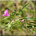
Cut-leaved Cranesbill (Geranium dissectum)
This was altogether new to me. It was on a small area of waste ground in the middle of the town. It is commoner further south.
Image: © Anne Burgess
Taken: 18 Jun 2014
0.05 miles
9
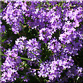
Fairy Foxglove (Erinus alpinus)
This is an introduced plant that like to grow in walls, and there are plenty of them on the walls along this lane. However this, the densest clump, is on an area of waste ground.
Image: © Anne Burgess
Taken: 18 Jun 2014
0.05 miles
10
Broad Lane West, Keith
With a red telephone kiosk in a garden on the right. A number of these were declared redundant and sold off by the Post Office a few years ago. This one seems to have found a new use as a mini-greenhouse.
Image: © Stanley Howe
Taken: 27 Aug 2013
0.06 miles


