IMAGES TAKEN NEAR TO
Cuthil Avenue, KEITH, AB55 5AQ
Introduction
This page details the photographs taken nearby to Cuthil Avenue, AB55 5AQ by members of the Geograph project.
The Geograph project started in 2005 with the aim of publishing, organising and preserving representative images for every square kilometre of Great Britain, Ireland and the Isle of Man.

There are currently over 7.5m images from over14,400 individuals and you can help contribute to the project by visiting https://www.geograph.org.uk
Image Map
Images are licensed for reuse under creativecommons.org/licenses/by-sa/2.0
Notes
- Clicking on the map will re-center to the selected point.
- The higher the marker number, the further away the image location is from the centre of the postcode.
Image Listing (142 Images Found)
Images are licensed for reuse under creativecommons.org/licenses/by-sa/2.0
Image
Details
Distance
1
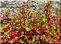
Shining Geranium (Geranium lucidum)
This is common and widespread in England and Wales, but more sporadic in Scotland. It's only been recorded in four grid squares in Banffshire before, but this lane and adjacent rough ground is chock-a-block with it.
Image: © Anne Burgess
Taken: 2 Jun 2023
0.05 miles
2
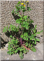
Smooth Sow-thistle (Sonchus oleraceus)
Not the most appealing of plants - you don't see cultivated varieties of Sonchus for sale in garden centres - but this is a rather fine specimen.
Image: © Anne Burgess
Taken: 2 Jun 2023
0.06 miles
3
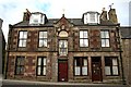
Chapel House
This house in Land Street has a curious pedimented central feature. I suspect that the doorway on the right is not original.
Image: © Anne Burgess
Taken: 6 Apr 2007
0.06 miles
4
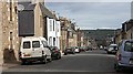
Land Street
The most westerly of Keith's three main streets is a wide and pleasant residential street.
Image: © Anne Burgess
Taken: 6 Apr 2007
0.06 miles
5
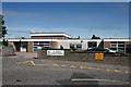
St Thomas' Primary School
I find it a little sad that the fine St Thomas' Church should be flanked by such a dreary concrete block sort of building. However it's what goes on inside that is important, and I don't doubt that it is entirely fit for purpose.
Image: © Anne Burgess
Taken: 18 Jun 2014
0.07 miles
6
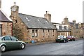
Land Street
The single-storey house nearest the camera is probably fairly typical of the original 18th century houses built along Land Street, though it would probably have been thatched, and would certainly not have had modern-style skylight windows. The dormers in the next cottage may also have been added when the thatch was replaced with slates. The third house has two storeys and pedimented dormer windows and is probably 19th century.
Image: © Anne Burgess
Taken: 16 Dec 2008
0.07 miles
7
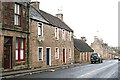
Land Street
The west side of Land Street. The small plaque above the door of the 18th century house with the three matching upstairs windows reads 'Skinners Inn', but I have yet to discover who the Skinners were and when they ran it as an inn. Note the orange and blue recycling boxes by the door of this and other houses further along the street. The single-storey cottage beyond is probably more typical of the original houses along the street.
Image: © Anne Burgess
Taken: 16 Dec 2008
0.07 miles
8
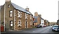
Land Street
Looking north from near the intersection with Chapel Street. Most of the houses date from the late 18th century, though several have been replaced with modern buildings.
Image: © Anne Burgess
Taken: 16 Dec 2008
0.07 miles
9
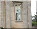
Wall mounted sculpture on St Thomas RC Church
To the right of the east door; St Paul?
Image: © Stanley Howe
Taken: 27 Aug 2013
0.08 miles
10
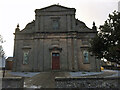
Keith, Roman Catholic Church
Keith, Roman Catholic Church, lovely building
Image: © thejackrustles
Taken: 1 Feb 2015
0.08 miles