IMAGES TAKEN NEAR TO
Dufftown, KEITH, AB55 4JT
Introduction
This page details the photographs taken nearby to AB55 4JT by members of the Geograph project.
The Geograph project started in 2005 with the aim of publishing, organising and preserving representative images for every square kilometre of Great Britain, Ireland and the Isle of Man.

There are currently over 7.5m images from over14,400 individuals and you can help contribute to the project by visiting https://www.geograph.org.uk
Image Map
Images are licensed for reuse under creativecommons.org/licenses/by-sa/2.0
Notes
- Clicking on the map will re-center to the selected point.
- The higher the marker number, the further away the image location is from the centre of the postcode.
Image Listing (6 Images Found)
Images are licensed for reuse under creativecommons.org/licenses/by-sa/2.0
Image
Details
Distance
1
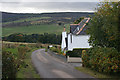
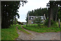
Tullich Cottage
The cottage stands beside a quiet minor road, with a fine view across Glen Fiddich to the slopes above Buchromb.
Image: © Anne Burgess
Taken: 8 Oct 2012
0.00 miles
2
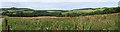
The View from Tullich
Strictly speaking this is the view from the road a few hundred yards above Tullich Farm. The pointed hill is the Knock of Buchromb, and the white buildings are at Broomhead.
Image: © Anne Burgess
Taken: 30 Jul 2020
0.11 miles
3
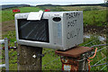
Recycling in Action
An old microwave oven makes an ideal postbox. Torbay is the large farm at the far end of the road.
Image: © Anne Burgess
Taken: 30 Jul 2020
0.17 miles
4
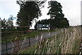
Blackhillock
A traditional stone house, just off the road, with a modern conservatory to take advantage of its south-facing situation.
Image: © Anne Burgess
Taken: 8 Oct 2012
0.20 miles
5
Blackhillock
Blackhillock stads just beside the public road above Tullich.
Image: © Anne Burgess
Taken: 30 Jul 2020
0.20 miles
6
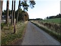
Minor road at Blackhillock
Looking north-eastward.
Image: © Peter Wood
Taken: 25 Oct 2018
0.21 miles