IMAGES TAKEN NEAR TO
Dufftown, KEITH, AB55 4JS
Introduction
This page details the photographs taken nearby to AB55 4JS by members of the Geograph project.
The Geograph project started in 2005 with the aim of publishing, organising and preserving representative images for every square kilometre of Great Britain, Ireland and the Isle of Man.

There are currently over 7.5m images from over14,400 individuals and you can help contribute to the project by visiting https://www.geograph.org.uk
Image Map
Images are licensed for reuse under creativecommons.org/licenses/by-sa/2.0
Notes
- Clicking on the map will re-center to the selected point.
- The higher the marker number, the further away the image location is from the centre of the postcode.
Image Listing (3 Images Found)
Images are licensed for reuse under creativecommons.org/licenses/by-sa/2.0
Image
Details
Distance
1
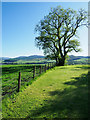
Tree in garden at Broomhead
Broomhead, on the slope above the east side of the valley of the River Fiddich, has a house and holiday cottages. Meikle Conval and Little Conval are in the distance.
Image: © Trevor Littlewood
Taken: 16 May 2019
0.02 miles
2
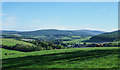
Grazing land at Broomhead
Low-angled, evening sunshine casts tree shadows over grazing land at Broomhead.
The small town of Dufftown can be seen in the valley at middle distance.
The most distant mountain will be Corryhabbie Hill.
Image: © Trevor Littlewood
Taken: 17 May 2019
0.04 miles
3
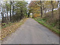
Tree-lined road near Bog of Kininvie
Looking north-westward.
Image: © Peter Wood
Taken: 25 Oct 2018
0.23 miles