IMAGES TAKEN NEAR TO
Glenrinnes, KEITH, AB55 4EW
Introduction
This page details the photographs taken nearby to AB55 4EW by members of the Geograph project.
The Geograph project started in 2005 with the aim of publishing, organising and preserving representative images for every square kilometre of Great Britain, Ireland and the Isle of Man.

There are currently over 7.5m images from over14,400 individuals and you can help contribute to the project by visiting https://www.geograph.org.uk
Image Map
Images are licensed for reuse under creativecommons.org/licenses/by-sa/2.0
Notes
- Clicking on the map will re-center to the selected point.
- The higher the marker number, the further away the image location is from the centre of the postcode.
Image Listing (28 Images Found)
Images are licensed for reuse under creativecommons.org/licenses/by-sa/2.0
Image
Details
Distance
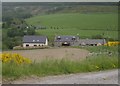
4
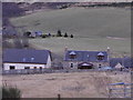
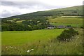
Hamlet of Convalleys
By Dullan Water; seen from the B9009.
Image: © Stanley Howe
Taken: 5 Mar 2015
0.12 miles
6
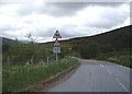
Approach to Bridge of Convalleys
Along B9009.
Image: © Stanley Howe
Taken: 4 Jun 2009
0.15 miles
7
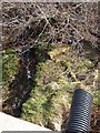
Burn of Convalleys
Looking downstream from the bridge.
Image: © Stanley Howe
Taken: 26 Mar 2007
0.16 miles
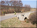
8
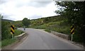
Bridge of Convalleys
On B9009 from Dufftown to Tomintoul.
Image: © Stanley Howe
Taken: 4 Jun 2009
0.16 miles
10
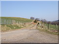
Track to Convalleys Farm
Entrance from the by-road to Bailliemore.
Image: © Stanley Howe
Taken: 26 Mar 2007
0.17 miles