IMAGES TAKEN NEAR TO
Dufftown, KEITH, AB55 4ED
Introduction
This page details the photographs taken nearby to AB55 4ED by members of the Geograph project.
The Geograph project started in 2005 with the aim of publishing, organising and preserving representative images for every square kilometre of Great Britain, Ireland and the Isle of Man.

There are currently over 7.5m images from over14,400 individuals and you can help contribute to the project by visiting https://www.geograph.org.uk
Image Map
Images are licensed for reuse under creativecommons.org/licenses/by-sa/2.0
Notes
- Clicking on the map will re-center to the selected point.
- The higher the marker number, the further away the image location is from the centre of the postcode.
Image Listing (5 Images Found)
Images are licensed for reuse under creativecommons.org/licenses/by-sa/2.0
Image
Details
Distance
1
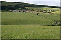
Newley
Newley is the farm on the left. Beyond there the road continues to Meirland, though I notice that the croft on the way has adopted the name 'Merlin Croft'.
Image: © Anne Burgess
Taken: 26 Jun 2007
0.02 miles
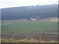
2

Newley
The Burn of Mackalea has been dammed here to create a pond, which makes a foreground for a view towards Newley above.
Image: © Anne Burgess
Taken: 22 Oct 2012
0.02 miles
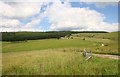
3

Harvesting at Newley
Newley is one of several farms perched high above the Burn of Mackalea north of the A920.
Image: © Anne Burgess
Taken: 22 Oct 2012
0.03 miles
4
Newley Farm
The access road leading to Newley and Meirland beyond with the wooded hill of Carran.
Image: © Andrew Wood
Taken: 23 Jul 2010
0.10 miles
5
View towards Newley
From A920 by Raehutcheon.
Image: © Stanley Howe
Taken: 26 Mar 2007
0.19 miles