IMAGES TAKEN NEAR TO
Dufftown, KEITH, AB55 4EB
Introduction
This page details the photographs taken nearby to AB55 4EB by members of the Geograph project.
The Geograph project started in 2005 with the aim of publishing, organising and preserving representative images for every square kilometre of Great Britain, Ireland and the Isle of Man.

There are currently over 7.5m images from over14,400 individuals and you can help contribute to the project by visiting https://www.geograph.org.uk
Image Map
Images are licensed for reuse under creativecommons.org/licenses/by-sa/2.0
Notes
- Clicking on the map will re-center to the selected point.
- The higher the marker number, the further away the image location is from the centre of the postcode.
Image Listing (5 Images Found)
Images are licensed for reuse under creativecommons.org/licenses/by-sa/2.0
Image
Details
Distance
2
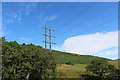
Nethertown Pylon
Powerlines coming off the Black Hill to supply properties around Clunymore and Milton of Auchindoun.
Image: © Andrew Wood
Taken: 16 Aug 2020
0.13 miles
3
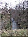
Looking upstream
Of Bell's Burn that joins the river Fiddich at Milltown of Auchindoun.
Image: © Stanley Howe
Taken: 26 Mar 2007
0.22 miles
5
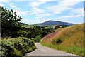
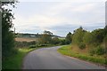
Downhill to Auchindoun
A view towards Ben Rinnes from above Milton of Auchindoun with a valley tree belt following the course of the Fiddich to Dufftown.
Image: © Andrew Wood
Taken: 16 Aug 2020
0.23 miles