IMAGES TAKEN NEAR TO
Dufftown, KEITH, AB55 4DU
Introduction
This page details the photographs taken nearby to AB55 4DU by members of the Geograph project.
The Geograph project started in 2005 with the aim of publishing, organising and preserving representative images for every square kilometre of Great Britain, Ireland and the Isle of Man.

There are currently over 7.5m images from over14,400 individuals and you can help contribute to the project by visiting https://www.geograph.org.uk
Image Map
Images are licensed for reuse under creativecommons.org/licenses/by-sa/2.0
Notes
- Clicking on the map will re-center to the selected point.
- The higher the marker number, the further away the image location is from the centre of the postcode.
Image Listing (14 Images Found)
Images are licensed for reuse under creativecommons.org/licenses/by-sa/2.0
Image
Details
Distance
1
Sandyhillock
Start of track off A920 to site of 'Gordon's Cross'.
Image: © Stanley Howe
Taken: 26 Mar 2007
0.12 miles
2
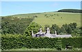
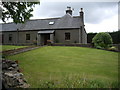
Sandyhillock
The roof of the farm house at Sandyhillock, and a view across the glen towards the Tips of Clunymore.
Image: © Anne Burgess
Taken: 24 Jun 2009
0.16 miles
3

Which Way?
Signpost showing the various walks around Dufftown
Image: © Ralph Greig
Taken: 23 Jan 2022
0.16 miles
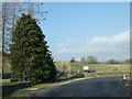
4
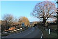
Bend in A941 at Sandyhilloch
Outskirts of Dufftown.
Image: © Stanley Howe
Taken: 5 Mar 2015
0.16 miles
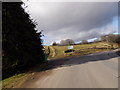
5
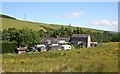
Sandyhillock Farmhouse
Looking across from the far side of the road to Pitglassie.
Image: © Anne Burgess
Taken: 24 Jun 2009
0.17 miles
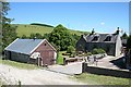
8
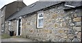
Sandyhillock
These are the cottages, which are to the east of the farm house.
Image: © Anne Burgess
Taken: 24 Jun 2009
0.19 miles
10
Hilltop Ruins
Farm ruins on the hilltop overlooking Dufftown.
Image: © Andrew Wood
Taken: 20 Feb 2016
0.20 miles