IMAGES TAKEN NEAR TO
Dufftown, KEITH, AB55 4BU
Introduction
This page details the photographs taken nearby to AB55 4BU by members of the Geograph project.
The Geograph project started in 2005 with the aim of publishing, organising and preserving representative images for every square kilometre of Great Britain, Ireland and the Isle of Man.

There are currently over 7.5m images from over14,400 individuals and you can help contribute to the project by visiting https://www.geograph.org.uk
Image Map
Images are licensed for reuse under creativecommons.org/licenses/by-sa/2.0
Notes
- Clicking on the map will re-center to the selected point.
- The higher the marker number, the further away the image location is from the centre of the postcode.
Image Listing (7 Images Found)
Images are licensed for reuse under creativecommons.org/licenses/by-sa/2.0
Image
Details
Distance
2
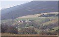
View towards Lettoch (NJ3037)
From near Nether Cluny. The peak of Ben Rinnes (841m) is just visible behind the slope of Meikle Conval.
Image: © Stanley Howe
Taken: 26 Mar 2007
0.12 miles
3
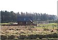
Blot on the landscape south of Home Farm.
Image: © Des Colhoun
Taken: 11 Oct 2006
0.17 miles
5
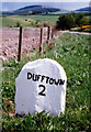
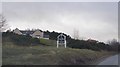
Old Milestone by the B9009, Mortlach Parish
By the B9009, in parish of Mortlach (Moray District), 2 mile South West of Dufftown, opposite pebble-dashed modern bungalow, North West side of road.
Inscription reads:- : DUFFTOWN / 2 : : AUCHBRECK / 9½ :
See also the other face: Image
Surveyed
Milestone Society National ID: MO_DTAU02
Image: © Milestone Society
Taken: Unknown
0.22 miles
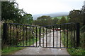
6
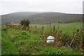
Milestone along the B9009 by Lettoch Brae.
Nine miles to Auchbreck.
Image: © Des Colhoun
Taken: 11 Oct 2006
0.23 miles
