IMAGES TAKEN NEAR TO
Dufftown, KEITH, AB55 4BP
Introduction
This page details the photographs taken nearby to AB55 4BP by members of the Geograph project.
The Geograph project started in 2005 with the aim of publishing, organising and preserving representative images for every square kilometre of Great Britain, Ireland and the Isle of Man.

There are currently over 7.5m images from over14,400 individuals and you can help contribute to the project by visiting https://www.geograph.org.uk
Image Map
Images are licensed for reuse under creativecommons.org/licenses/by-sa/2.0
Notes
- Clicking on the map will re-center to the selected point.
- The higher the marker number, the further away the image location is from the centre of the postcode.
Image Listing (6 Images Found)
Images are licensed for reuse under creativecommons.org/licenses/by-sa/2.0
Image
Details
Distance
1
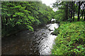
River Fiddich
Looking upstream from the footbridge between Balvenie and Tulloch.
Image: © Anne Burgess
Taken: 30 Jul 2020
0.06 miles
2
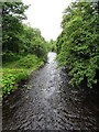
River Fiddich
Looking downstream from the footbridge between Balvenie and Tulloch.
Image: © Anne Burgess
Taken: 30 Jul 2020
0.08 miles
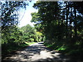
4
Minor road near Tullich
Looking southward.
Image: © Peter Wood
Taken: 25 Oct 2018
0.21 miles
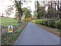
5
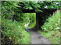
The Speyside Way Dufftown Spur near Balvenie
Image: © Dave Kelly
Taken: 15 Sep 2017
0.22 miles
6
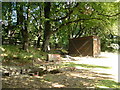
Weight for it
56 pound weights, buckets attached to hawsers over pulleys in the trees; what could it be? This is the training ground for the Dufftown Tug of War Team.
Image: © alan souter
Taken: 25 Aug 2006
0.24 miles