IMAGES TAKEN NEAR TO
Church Street, KEITH, AB55 4AR
Introduction
This page details the photographs taken nearby to Church Street, AB55 4AR by members of the Geograph project.
The Geograph project started in 2005 with the aim of publishing, organising and preserving representative images for every square kilometre of Great Britain, Ireland and the Isle of Man.

There are currently over 7.5m images from over14,400 individuals and you can help contribute to the project by visiting https://www.geograph.org.uk
Image Map
Images are licensed for reuse under creativecommons.org/licenses/by-sa/2.0
Notes
- Clicking on the map will re-center to the selected point.
- The higher the marker number, the further away the image location is from the centre of the postcode.
Image Listing (128 Images Found)
Images are licensed for reuse under creativecommons.org/licenses/by-sa/2.0
Image
Details
Distance
1
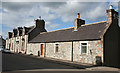
Church Street
Traditional stone houses and cottage on the east side of Church Street.
Image: © Anne Burgess
Taken: 10 Apr 2014
0.01 miles
2
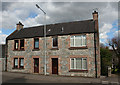
44 and 44a Church Street
A pair of stone semi-detached houses, their symmetry destroyed by the non-matching windows.
Image: © Anne Burgess
Taken: 10 Apr 2014
0.02 miles
3
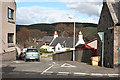
Braehead Terrace
The map shows this as Stephen Avenue, but the name plates at both ends read Braehead Terrace.
Image: © Anne Burgess
Taken: 10 Apr 2014
0.02 miles
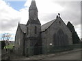
5
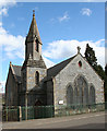
United Free Kirk
That should probably read 'former United Free Kirk' because it has a rather disused air about it. Information about it is a little sparse, but it seems to have been built in 1891-1892 as a replacement of the original Free Kirk by James Souttar or his son James Alexander Souttar. Newspaper reports mentioning the Free Church stop in 1897, and are followed from 1903 to 1909 by references to the United Free Church. More research is called for; but in the meantime, if anyone knows any more about it I will be pleased to hear from them.
Image: © Anne Burgess
Taken: 10 Apr 2014
0.04 miles
6
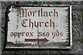
It's that way!
This rather battered notice is on the wall of Image'>Image One can only imagine how many times a stranger seeking Mortlach Parish Kirk has mistaken this for his destination. Perhaps whole funeral or wedding parties have been misled, or the congregation here plagued by people arriving at the wrong building. The sign isn't going to last much longer now, but maybe the advent of satellite navigation systems will render it unncessary at last - though I'd trust a sign like this before I'd trust a satnav!
Image: © Anne Burgess
Taken: 10 Apr 2014
0.04 miles
7
Glenfiddich Licensed Restaurant, 13 Church Street
Image: © Nick Mutton 01329 000000
Taken: 7 Aug 2007
0.04 miles
8

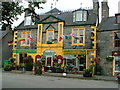
Church Street
When I drove into Dufftown this morning I was a little surprised to see that the Christmas lights were still in place in Balvenie Street. On reaching Church Street, however, there was a vehicle and crew busy taking them down. The gaudy façade on the left is that of the notorious Glenfiddich Café, which sticks in my memory as being the first place I ever encountered where there was a charge for a glass of tap water. I have not darkened its door since that day almost thirty years ago. For a different take on this establishment see Image] - though serving 'Dufftowns finest' [sic] is hardly unique to here.
Image: © Anne Burgess
Taken: 22 Feb 2011
0.05 miles
10
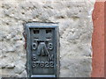
Ordnance Survey Flush Bracket S7622
This can be found on the wall of a building in Church Street, Dufftown. The benchmark height is recorded as being 188.939 metres above sea level.
For more detail see : https://www.bench-marks.org.uk/bm21072
Image: © Peter Wood
Taken: 25 Oct 2018
0.07 miles