IMAGES TAKEN NEAR TO
Fife Street, KEITH, AB55 4AQ
Introduction
This page details the photographs taken nearby to Fife Street, AB55 4AQ by members of the Geograph project.
The Geograph project started in 2005 with the aim of publishing, organising and preserving representative images for every square kilometre of Great Britain, Ireland and the Isle of Man.

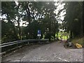
There are currently over 7.5m images from over14,400 individuals and you can help contribute to the project by visiting https://www.geograph.org.uk
Image Map
Images are licensed for reuse under creativecommons.org/licenses/by-sa/2.0
Notes
- Clicking on the map will re-center to the selected point.
- The higher the marker number, the further away the image location is from the centre of the postcode.
Image Listing (53 Images Found)
Images are licensed for reuse under creativecommons.org/licenses/by-sa/2.0
Image
Details
Distance
2
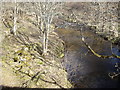
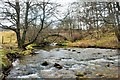
Upstream Dullan Water
From Bridge of Crichie, Dufftown.
Image: © Stanley Howe
Taken: 10 Mar 2009
0.07 miles
5
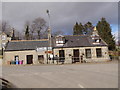
Eastern entrance to Dufftown
Via A941. Junction of A941 with B9014.
Image: © Stanley Howe
Taken: 5 Mar 2015
0.07 miles
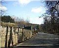
7
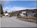
Road junction by Bridge of Crachie
In Dufftown; B9014 going north from A941.
Image: © Stanley Howe
Taken: 5 Mar 2015
0.08 miles
8
Dullan at Crachie
The Dullan Water just yards away from flowing into the Fiddich at bridge of Crachie.
Image: © Andrew Wood
Taken: 20 Feb 2016
0.09 miles
9
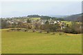
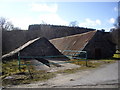
Hilltop Ruins
Farm ruins on the hilltop overlooking Dufftown.
Image: © Andrew Wood
Taken: 20 Feb 2016
0.09 miles
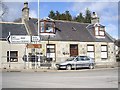
10
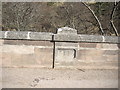
Bridge of Crachie, Dufftown
Over Dullan Water; date stone 1949 inset in NE parapet.
Image: © Stanley Howe
Taken: 10 Mar 2009
0.11 miles