IMAGES TAKEN NEAR TO
Conval Street, KEITH, AB55 4AE
Introduction
This page details the photographs taken nearby to Conval Street, AB55 4AE by members of the Geograph project.
The Geograph project started in 2005 with the aim of publishing, organising and preserving representative images for every square kilometre of Great Britain, Ireland and the Isle of Man.

There are currently over 7.5m images from over14,400 individuals and you can help contribute to the project by visiting https://www.geograph.org.uk
Image Map
Images are licensed for reuse under creativecommons.org/licenses/by-sa/2.0
Notes
- Clicking on the map will re-center to the selected point.
- The higher the marker number, the further away the image location is from the centre of the postcode.
Image Listing (117 Images Found)
Images are licensed for reuse under creativecommons.org/licenses/by-sa/2.0
Image
Details
Distance
1
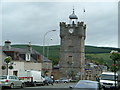
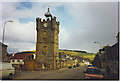
Dufftown Clock Tower (A941)
Image: © Nick Mutton 01329 000000
Taken: 7 Aug 2007
0.00 miles
2
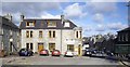
The Square, Dufftown
Northwest corner.
Image: © Stanley Howe
Taken: 10 Mar 2009
0.02 miles
3
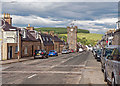
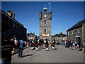
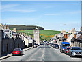
Conval Street Dufftown
Looking east along the B9009 towards the Clock Tower that dominates the centre of Dufftown
Image: © valenta
Taken: 15 Jun 2018
0.02 miles
5
The Tower, Dufftown.
In the middle of Whisky Country.
Image: © Colin Smith
Taken: Unknown
0.03 miles
6
Clock Tower, Dufftown
The Clock Tower at Dufftown with the Dufftown and District Pipe Band performing during The Spirit of Speyside Whisky Festival April 30th, 2006. A plaque on the tower remembers a Dufftown man who founded the Canadian Pacific Railway.
Image: © Christopher Gillan
Taken: 30 Apr 2006
0.03 miles
7
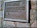
Plaque to George Stephen (Lord Mountstephen)
Mounted on the wall of the tower in the centre of Dufftown. Stephen was a famous son of the town, who sponsored the Canadian Pacific Railway.
Image: © Stanley Howe
Taken: 6 Sep 2003
0.03 miles
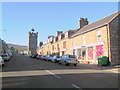
8
Dufftown Clock Tower
The clock tower stands prominently at the centre of the town. It was constructed as a jail, then saw use as the Burgh Chambers; it's now (2019), an information office.
Image: © Trevor Littlewood
Taken: 17 May 2019
0.03 miles
9
Ordnance Survey Cut Mark
This mark can be found on the wall of The Tower in The Square, Dufftown. The benchmark height is recorded as being 187.715 metres above sea level.
For more detail see : https://www.bench-marks.org.uk/bm101696
Image: © Peter Wood
Taken: 21 Oct 2018
0.03 miles
10
'La Faisanderie' restaurant, Dufftown
Viewed from close to the town clock tower.
Image: © Stanley Howe
Taken: 5 Mar 2015
0.03 miles