IMAGES TAKEN NEAR TO
AB55 3JZ
Introduction
This page details the photographs taken nearby to AB55 3JZ by members of the Geograph project.
The Geograph project started in 2005 with the aim of publishing, organising and preserving representative images for every square kilometre of Great Britain, Ireland and the Isle of Man.

There are currently over 7.5m images from over14,400 individuals and you can help contribute to the project by visiting https://www.geograph.org.uk
Image Map
Images are licensed for reuse under creativecommons.org/licenses/by-sa/2.0
Notes
- Clicking on the map will re-center to the selected point.
- The higher the marker number, the further away the image location is from the centre of the postcode.
Image Listing (12 Images Found)
Images are licensed for reuse under creativecommons.org/licenses/by-sa/2.0
Image
Details
Distance
2
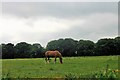
Horse by Treeline
A horse grazing in pasture in front of the Denburn woodland.
Image: © Andrew Wood
Taken: 3 Jun 2018
0.17 miles
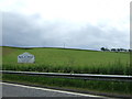
4
Welcome to Keith
The signs proclaim Keith as 'The Friendly Town', which in my experience is entirely justified. The road is the A96 trunk road between Aberdeen and Inverness, which is often very busy, and at the moment is infested with roadworks and temporary traffic lights. There is little likelihood of a bypass in the near future.
Image: © Anne Burgess
Taken: 25 Feb 2009
0.18 miles
5
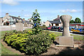
Sculptures on Moss Street
This little triangle of garden is the first thing you pass as you enter Keith from the south on the A96. Never having actually walked past here before, I had totally failed to notice the two pieces of art in the flowerbed. On the plinth to the left is a bowl carved with a thistle design, and on the right a sheaf of grain. I know not who the sculptor(s) is/are, or when they were placed here, or at whose expense, and for once Google is not my friend!
Image: © Anne Burgess
Taken: 18 Jun 2014
0.19 miles
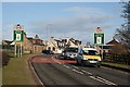
6
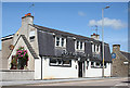
Royal Oak Inn
The first pub as you arrive in keith has been closed for years. It's probably just as well to get this photograph now, before the window frames fall apart and the whole building begins to crumble.
Image: © Anne Burgess
Taken: 18 Jun 2014
0.21 miles
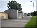
7
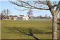
Keith Showground
The buildings at the far side of the Showground are the premises of the Banffshire Farmers' Society, which runs the annual show.
Image: © Anne Burgess
Taken: 25 Feb 2009
0.21 miles
8
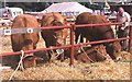
Keith Show
Prize cattle at the annual agricultural show, a highlight of the calendar in Keith.
Image: © Anne Burgess
Taken: 9 Aug 1983
0.23 miles
9
Agricultural Society buildings, Keith
By Seafield Park.
Image: © Stanley Howe
Taken: 27 Aug 2013
0.24 miles
10
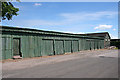
Sheds at Seafield Park
The sheds are used in connection with the Keith Country Show. Their plain utilitarian style is enlivened by the carvings in the wood along the top of the walls.
Image: © Anne Burgess
Taken: 18 Jun 2014
0.24 miles