IMAGES TAKEN NEAR TO
Tarryblake, HUNTLY, AB54 7PD
Introduction
This page details the photographs taken nearby to AB54 7PD by members of the Geograph project.
The Geograph project started in 2005 with the aim of publishing, organising and preserving representative images for every square kilometre of Great Britain, Ireland and the Isle of Man.

There are currently over 7.5m images from over14,400 individuals and you can help contribute to the project by visiting https://www.geograph.org.uk
Image Map
Images are licensed for reuse under creativecommons.org/licenses/by-sa/2.0
Notes
- Clicking on the map will re-center to the selected point.
- The higher the marker number, the further away the image location is from the centre of the postcode.
Image Listing (5 Images Found)
Images are licensed for reuse under creativecommons.org/licenses/by-sa/2.0
Image
Details
Distance
1
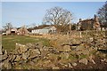
Viewfield
The farm buildings and farm house, with an interesting drystane dyke in the foreground.
Image: © Anne Burgess
Taken: 15 Feb 2008
0.01 miles
2
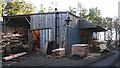
Tarryblake Sawmill
A slightly ramshackle-looking building houses the saws.
Image: © Anne Burgess
Taken: 15 Feb 2008
0.12 miles
3
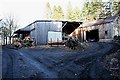
Tarryblake Sawmill
Piles of waste timber surround the main shed, where the saw was hard at work as I approached.
Image: © Anne Burgess
Taken: 15 Feb 2008
0.12 miles
4
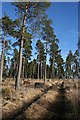
Tarryblake Wood
Each of the access points to this tract of open woodland has a notice welcoming walkers, and even inviting walkers to park at the fringe of the wood.
Image: © Anne Burgess
Taken: 15 Feb 2008
0.17 miles
5
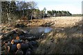
Frozen Pond
This small pond is completely frozen over, though not thickly enough to take weight.
Image: © Anne Burgess
Taken: 15 Feb 2008
0.23 miles