IMAGES TAKEN NEAR TO
Rothiemay, HUNTLY, AB54 7PB
Introduction
This page details the photographs taken nearby to AB54 7PB by members of the Geograph project.
The Geograph project started in 2005 with the aim of publishing, organising and preserving representative images for every square kilometre of Great Britain, Ireland and the Isle of Man.

There are currently over 7.5m images from over14,400 individuals and you can help contribute to the project by visiting https://www.geograph.org.uk
Image Map
Images are licensed for reuse under creativecommons.org/licenses/by-sa/2.0
Notes
- Clicking on the map will re-center to the selected point.
- The higher the marker number, the further away the image location is from the centre of the postcode.
Image Listing (2 Images Found)
Images are licensed for reuse under creativecommons.org/licenses/by-sa/2.0
Image
Details
Distance
1
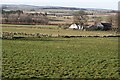
Tarryblake Home Farm
It's quite unusual to find both a Home Farm and a main, but Tarryblake has both. The house itself is well screened by trees and not visible from the road.
Image: © Anne Burgess
Taken: 15 Feb 2008
0.02 miles
2
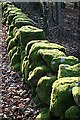
Moss-covered Dyke
The dyke is in the shade of beech woodland, allowing thick green moss to cover the stones like a row of velvet cushions.
Image: © Anne Burgess
Taken: 15 Feb 2008
0.16 miles