IMAGES TAKEN NEAR TO
Rothiemay, HUNTLY, AB54 7PA
Introduction
This page details the photographs taken nearby to AB54 7PA by members of the Geograph project.
The Geograph project started in 2005 with the aim of publishing, organising and preserving representative images for every square kilometre of Great Britain, Ireland and the Isle of Man.

There are currently over 7.5m images from over14,400 individuals and you can help contribute to the project by visiting https://www.geograph.org.uk
Image Map
Images are licensed for reuse under creativecommons.org/licenses/by-sa/2.0
Notes
- Clicking on the map will re-center to the selected point.
- The higher the marker number, the further away the image location is from the centre of the postcode.
Image Listing (6 Images Found)
Images are licensed for reuse under creativecommons.org/licenses/by-sa/2.0
Image
Details
Distance
2
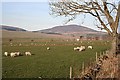
Looking Towards Knock Hill
Knock Hill is in a distant square, but it dominates the countryside around here. The foreground, and the electricity transformer beyond the sheep, are all in square.
Image: © Anne Burgess
Taken: 15 Feb 2008
0.15 miles
3
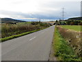
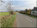
Road (B9117) approaching Burnside
Looking north-westward.
Image: © Peter Wood
Taken: 23 Oct 2018
0.15 miles
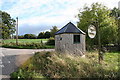
4
Road (B9117) at Burnside
Looking south-eastward.
Image: © Peter Wood
Taken: 23 Oct 2018
0.20 miles
5
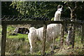
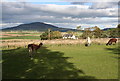
A curious llama in a most curious setting!!
Image: © Des Colhoun
Taken: 8 Oct 2006
0.23 miles