IMAGES TAKEN NEAR TO
Rothiemay, HUNTLY, AB54 7NB
Introduction
This page details the photographs taken nearby to AB54 7NB by members of the Geograph project.
The Geograph project started in 2005 with the aim of publishing, organising and preserving representative images for every square kilometre of Great Britain, Ireland and the Isle of Man.

There are currently over 7.5m images from over14,400 individuals and you can help contribute to the project by visiting https://www.geograph.org.uk
Image Map
Images are licensed for reuse under creativecommons.org/licenses/by-sa/2.0
Notes
- Clicking on the map will re-center to the selected point.
- The higher the marker number, the further away the image location is from the centre of the postcode.
Image Listing (8 Images Found)
Images are licensed for reuse under creativecommons.org/licenses/by-sa/2.0
Image
Details
Distance
1
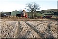
South Redhill
I understand that this steading will not long be housing cattle; it is shortly to be converted to houses.
Image: © Anne Burgess
Taken: 15 Feb 2008
0.04 miles
2
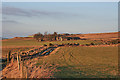
North and South Redhill
The maps are slightly misleading here, because they imply that there is no road between Auchinbo and Redhill. In fact there is a perfectly walkable track all the way. The nearer farm is South Redhill, and north Redhill is beyond, on the skyline. Late afternoon winter sunshine gives them a colour to match their name.
Image: © Anne Burgess
Taken: 11 Feb 2015
0.05 miles
3
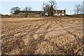
North Redhill
The grid line passes through this farm, but the rather military-looking shed in front of the steading is in square.
Image: © Anne Burgess
Taken: 15 Feb 2008
0.17 miles
4
Redhill
Farm on the slopes of the Fourman.
Image: © Richard Webb
Taken: 6 Aug 2007
0.19 miles
5
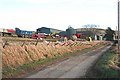
North Redhill
A colourful collection of farm machinery awaits use at North Redhill.
Image: © Anne Burgess
Taken: 15 Feb 2008
0.21 miles
6
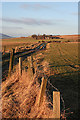
Track to South Redhill
The rather rickety state of the fences by the track suggests that livestock are no longer grazed on these fields.
Image: © Anne Burgess
Taken: 11 Feb 2015
0.22 miles
7
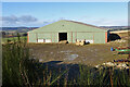
Barn at North Redhill
A large new barn beside the farm of North Redhill.
Image: © Anne Burgess
Taken: 4 Feb 2022
0.23 miles
8
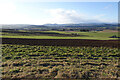
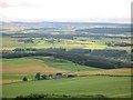
Carse of Kinnoir
Picking a subject point here is a bit arbitrary. The prominent peak on the skyline is Tap o' Noth. To its right, with some wisps of white cloud rising off it, is The Buck, and the slightly nearer low ridge extending to the right again is Clashmach Hill. Lower, and forested, is the Bin of Huntly. To the left of Tap o' Noth, lower down, is Kinnoir Wood. The low-lying ground is the Carse of Kinnoir, and the row of grey sheds is at Rivestone.
Image: © Anne Burgess
Taken: 4 Feb 2022
0.24 miles