IMAGES TAKEN NEAR TO
Knock, HUNTLY, AB54 7LQ
Introduction
This page details the photographs taken nearby to AB54 7LQ by members of the Geograph project.
The Geograph project started in 2005 with the aim of publishing, organising and preserving representative images for every square kilometre of Great Britain, Ireland and the Isle of Man.

There are currently over 7.5m images from over14,400 individuals and you can help contribute to the project by visiting https://www.geograph.org.uk
Image Map
Images are licensed for reuse under creativecommons.org/licenses/by-sa/2.0
Notes
- Clicking on the map will re-center to the selected point.
- The higher the marker number, the further away the image location is from the centre of the postcode.
Image Listing (4 Images Found)
Images are licensed for reuse under creativecommons.org/licenses/by-sa/2.0
Image
Details
Distance
1
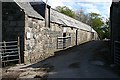
Ternemny
An old farm steading at Ternemny, with the public road running between it and the more modern farm buildings on the right.
Image: © Anne Burgess
Taken: 14 May 2007
0.03 miles
2
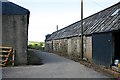
Ternemny
Unusually, the public road passes between the farm buildings at Ternemny.
Image: © Anne Burgess
Taken: 14 May 2007
0.03 miles
3
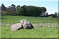
Ternemny
This large boulder, almost certainly an erratic, has evidently proved too much of a challenge for field clearance. Ternemny farm house is on the right.
Image: © Anne Burgess
Taken: 14 May 2007
0.08 miles
4
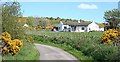
Ramsburn
The nearer house is Ramsburn Croft, and the gable on the left is Ramsburn Cottage.
Image: © Anne Burgess
Taken: 14 May 2007
0.22 miles