IMAGES TAKEN NEAR TO
Rothiemay, HUNTLY, AB54 7JS
Introduction
This page details the photographs taken nearby to AB54 7JS by members of the Geograph project.
The Geograph project started in 2005 with the aim of publishing, organising and preserving representative images for every square kilometre of Great Britain, Ireland and the Isle of Man.

There are currently over 7.5m images from over14,400 individuals and you can help contribute to the project by visiting https://www.geograph.org.uk
Image Map
Images are licensed for reuse under creativecommons.org/licenses/by-sa/2.0
Notes
- Clicking on the map will re-center to the selected point.
- The higher the marker number, the further away the image location is from the centre of the postcode.
Image Listing (7 Images Found)
Images are licensed for reuse under creativecommons.org/licenses/by-sa/2.0
Image
Details
Distance
1
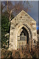
Old Church Doorway and Bell
Commemorates a church which stood here and was dismantled in 1958.
Image: © Alan hodgson
Taken: 15 Nov 2018
0.02 miles
2

Comfrey (Symphytum sp)
Almost certainly Russian Comfrey (S x uplandicum), which is a hybrid between the native Common Comfrey (S officinale) and the introduced Rough Comfrey (S asperum). For some reason the hybrid is more widespread than either of its parent plants.
Image: © Anne Burgess
Taken: 18 Jun 2014
0.05 miles
3
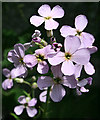
Dame's Violet (Hesperus matronalis)
A common wayside plant, with tall spikes of either lilac or white flowers. Apparently whoever bestowed its Latin name did not realise that 'dame' is a reference to Damascus, not to mature or eminent ladies.
Image: © Anne Burgess
Taken: 18 Jun 2014
0.05 miles
4
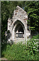
Kirk Doorway
Intrigued by a kirk symbol on the 1976 1:50,000 map which was not repeated on the 2002 1:25,000, I went to investigate and found this. The plaque explains.
Image: © Anne Burgess
Taken: 18 Jun 2014
0.05 miles
5
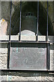
Plaque and Bell
The inscription reads, "This doorway and bell commeorate the church which at the Disruption of 1843 became the Free Church of Scotland in the parish of Rothiemay. In 1900, after joining with the United Presbyterian Church, it became the United Free Church. It rejoined the Church of Scotland in 1929 and was dismantled in 1958."
Image: © Anne Burgess
Taken: 18 Jun 2014
0.05 miles
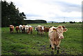
6
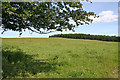
Mannoch Hill
It's a very modest hill, at only 162 metres, but also one of those where it isn't easy to pinpoint the exact summit.
Image: © Anne Burgess
Taken: 18 Jun 2014
0.14 miles