IMAGES TAKEN NEAR TO
Glass, HUNTLY, AB54 4YX
Introduction
This page details the photographs taken nearby to AB54 4YX by members of the Geograph project.
The Geograph project started in 2005 with the aim of publishing, organising and preserving representative images for every square kilometre of Great Britain, Ireland and the Isle of Man.

There are currently over 7.5m images from over14,400 individuals and you can help contribute to the project by visiting https://www.geograph.org.uk
Image Map
Images are licensed for reuse under creativecommons.org/licenses/by-sa/2.0
Notes
- Clicking on the map will re-center to the selected point.
- The higher the marker number, the further away the image location is from the centre of the postcode.
Image Listing (8 Images Found)
Images are licensed for reuse under creativecommons.org/licenses/by-sa/2.0
Image
Details
Distance
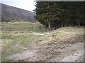
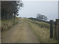
1
Wester Braetown
This is the end of the public road. A ford, shown on the maps, has been bypassed by a bridge carrying the tracks to both Wester and Easter Braetown.
Image: © Anne Burgess
Taken: 3 Apr 2009
0.02 miles
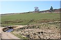
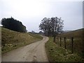
2
Access to Wester Braetown
From the end of the public road up Glen Markie.
Image: © Stanley Howe
Taken: 21 Mar 2009
0.03 miles
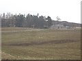
3
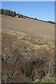
Easter Braetown
Easter Braetown stands high above the Water of Markie, a fine situation in good weather, but it would have been a different matter in the deep snows of yesteryear.
Image: © Anne Burgess
Taken: 3 Apr 2009
0.16 miles
4
Track to Newtown of Glenmarkie
From end of public road.
Image: © Stanley Howe
Taken: 21 Mar 2009
0.16 miles
5
Approach to end of public road near Braetown
Image: © Stanley Howe
Taken: 21 Mar 2009
0.17 miles
6
Easter Braetown
From end of public road up Glenmarkie.
Image: © Stanley Howe
Taken: 21 Mar 2009
0.18 miles
7
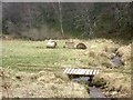
Wee bridge over the Ravoch Burn
Near its confluence with Markie Water.
Image: © Stanley Howe
Taken: 21 Mar 2009
0.23 miles