IMAGES TAKEN NEAR TO
Lower Cabrach, HUNTLY, AB54 4EU
Introduction
This page details the photographs taken nearby to AB54 4EU by members of the Geograph project.
The Geograph project started in 2005 with the aim of publishing, organising and preserving representative images for every square kilometre of Great Britain, Ireland and the Isle of Man.

There are currently over 7.5m images from over14,400 individuals and you can help contribute to the project by visiting https://www.geograph.org.uk
Image Map
Images are licensed for reuse under creativecommons.org/licenses/by-sa/2.0
Notes
- Clicking on the map will re-center to the selected point.
- The higher the marker number, the further away the image location is from the centre of the postcode.
Image Listing (34 Images Found)
Images are licensed for reuse under creativecommons.org/licenses/by-sa/2.0
Image
Details
Distance
1
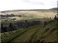
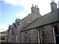
Cabrach Primary School
Seen from track to Tombain.
Image: © Stanley Howe
Taken: 10 Mar 2009
0.02 miles
2
Lower Cabrach Church
Originally Strathdeveron there are two distinct districts, the Upper and the Lower Cabrach.
Image: © Andrew Wood
Taken: Unknown
0.08 miles
3
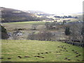
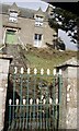
View towards Inverharroch farm
From track from Tombain.
Image: © Stanley Howe
Taken: 10 Mar 2009
0.08 miles
4
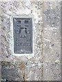
OSBM Wallbracket
OS Bench Mark S7523 built into the NW corner of Lower Cabrach church.
Image: © Stanley Howe
Taken: 10 Mar 2009
0.08 miles
7
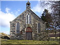
Lower Cabrach Church
A close up view of the church.
Image: © Andrew Wood
Taken: 23 Jul 2010
0.08 miles
9
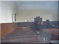
Lower Cabrach church interior (North)
The side without windows.
Image: © Stanley Howe
Taken: 10 Mar 2009
0.08 miles
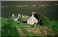
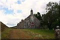
10
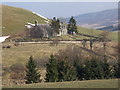
Lower Cabrach church and manse
Seen from A941.
Image: © Stanley Howe
Taken: 26 Mar 2007
0.09 miles