IMAGES TAKEN NEAR TO
Lower Cabrach, HUNTLY, AB54 4EP
Introduction
This page details the photographs taken nearby to AB54 4EP by members of the Geograph project.
The Geograph project started in 2005 with the aim of publishing, organising and preserving representative images for every square kilometre of Great Britain, Ireland and the Isle of Man.

There are currently over 7.5m images from over14,400 individuals and you can help contribute to the project by visiting https://www.geograph.org.uk
Image Map
Images are licensed for reuse under creativecommons.org/licenses/by-sa/2.0
Notes
- Clicking on the map will re-center to the selected point.
- The higher the marker number, the further away the image location is from the centre of the postcode.
Image Listing (19 Images Found)
Images are licensed for reuse under creativecommons.org/licenses/by-sa/2.0
Image
Details
Distance
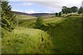
4
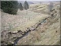
Downstream Burn of Succoth
From the bridge on the Cabrach road.
Image: © Stanley Howe
Taken: 10 Mar 2009
0.13 miles
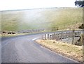
5
Road crossing the Bridge of Forteath near Craiglewe
Looking south-westward.
Image: © Peter Wood
Taken: 21 Oct 2018
0.16 miles
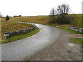
6
Bridge of Succoth
On road from Cabrach to Haugh of Glass.
Image: © Stanley Howe
Taken: 10 Mar 2009
0.16 miles
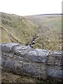
7
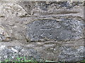
Ordnance Survey Cut Mark
This mark can be found on the roadside stonework of the Bridge of Forteath. The benchmark height is recorded as being 290.289 metres above sea level.
For more detail see : https://www.bench-marks.org.uk/bm101697
Image: © Peter Wood
Taken: 21 Oct 2018
0.17 miles
9
Upstream Burn of Succoth
From the bridge on the Cabrach road.
Image: © Stanley Howe
Taken: 10 Mar 2009
0.20 miles