IMAGES TAKEN NEAR TO
Fordyce, BANFF, AB45 2XR
Introduction
This page details the photographs taken nearby to AB45 2XR by members of the Geograph project.
The Geograph project started in 2005 with the aim of publishing, organising and preserving representative images for every square kilometre of Great Britain, Ireland and the Isle of Man.

There are currently over 7.5m images from over14,400 individuals and you can help contribute to the project by visiting https://www.geograph.org.uk
Image Map
Images are licensed for reuse under creativecommons.org/licenses/by-sa/2.0
Notes
- Clicking on the map will re-center to the selected point.
- The higher the marker number, the further away the image location is from the centre of the postcode.
Image Listing (2 Images Found)
Images are licensed for reuse under creativecommons.org/licenses/by-sa/2.0
Image
Details
Distance
1
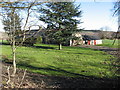
Un-named Cottage near Fordyce
This attractive cottage appears to be a conversion and is situated between Upper Breach and Little Cultain.
Image: © Christopher Gillan
Taken: 2 Mar 2007
0.15 miles
2
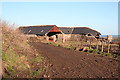
Upper Breach Steading
This old building has evidently outlived its usefulness, like so many others in the area.
Image: © Anne Burgess
Taken: 20 Jan 2011
0.23 miles