IMAGES TAKEN NEAR TO
Craigellachie, ABERLOUR, AB38 9SJ
Introduction
This page details the photographs taken nearby to AB38 9SJ by members of the Geograph project.
The Geograph project started in 2005 with the aim of publishing, organising and preserving representative images for every square kilometre of Great Britain, Ireland and the Isle of Man.

There are currently over 7.5m images from over14,400 individuals and you can help contribute to the project by visiting https://www.geograph.org.uk
Image Map
Images are licensed for reuse under creativecommons.org/licenses/by-sa/2.0
Notes
- Clicking on the map will re-center to the selected point.
- The higher the marker number, the further away the image location is from the centre of the postcode.
Image Listing (5 Images Found)
Images are licensed for reuse under creativecommons.org/licenses/by-sa/2.0
Image
Details
Distance
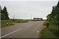
1
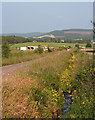
Country Road
The road is arrow-straight, and the ditch beside it is bright with Monkey Flower (Mimulus guttatus). There's building going on further down, beside what looks like a loosebox, and people are out for a walk in evening sunshine. The prominent scar on the hillside in the distance is Blue Hill Quarry.
Image: © Anne Burgess
Taken: 10 Jul 2013
0.15 miles
4
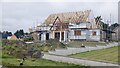
Glass gabled house under construction
A triangle of steel where the glass will go.
Image: © Richard Webb
Taken: 26 Aug 2021
0.23 miles
5
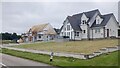
New houses, Blackholes
The by now familiar glass gables.
Image: © Richard Webb
Taken: 26 Aug 2021
0.23 miles