IMAGES TAKEN NEAR TO
Craigellachie, ABERLOUR, AB38 9RT
Introduction
This page details the photographs taken nearby to AB38 9RT by members of the Geograph project.
The Geograph project started in 2005 with the aim of publishing, organising and preserving representative images for every square kilometre of Great Britain, Ireland and the Isle of Man.

There are currently over 7.5m images from over14,400 individuals and you can help contribute to the project by visiting https://www.geograph.org.uk
Image Map
Images are licensed for reuse under creativecommons.org/licenses/by-sa/2.0
Notes
- Clicking on the map will re-center to the selected point.
- The higher the marker number, the further away the image location is from the centre of the postcode.
Image Listing (6 Images Found)
Images are licensed for reuse under creativecommons.org/licenses/by-sa/2.0
Image
Details
Distance
2
Road junction at Dandaleith
B9102 meeting A941.
Image: © Stanley Howe
Taken: 7 Oct 2008
0.12 miles
3
Dandaleith station (site, ?remains)
View eastward from the A941 road in the Spey Valley. The house may belong to the former station, which was on the ex-Great North of Scotland main line from Aberdeen to Elgin via Craigellachie. The station became a Halt in its latter days and was closed 5/3/62, before the line between Elgin and Craigellachie closed on 18/11/65 in favour of the former Highland Railway line between Keith and Elgin which has subsequently become the route for the Aberdeen - Elgin - Inverness services.
Edit by Anne Burgess, 2019. This house was not in fact part of the station buildings. The station buildings were on the west side of the line https://maps.nls.uk/geo/explore/side-by-side/#zoom=17&lat=57.4982&lon=-3.1900&layers=168&right=BingHyb. The First Edition of the Ordnance Survey Six-inch map https://maps.nls.uk/geo/explore/side-by-side/#zoom=17&lat=57.4980&lon=-3.1898&layers=5&right=BingHyb names the house on that site as Newfield Cottage, and the 1:25,000 map places it 100 metres from the nearest point on the line of the railway and 200 metres from the site of the station. Note that the later map names the house as Dandaleith, not Newfield Cottage. From the shape of the building on the two maps, and the style of the building, and the change of name, it is probable that the present house was built in the second half of the 19th century to replace Newfield Cottage.
Image: © Ben Brooksbank
Taken: 3 Jul 1997
0.14 miles
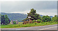
4
B9102/A941 junction
The B road climbs hard away from the Spey, soon passing the Macallan distillery.
Image: © Richard Webb
Taken: 26 Aug 2021
0.17 miles
5
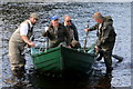
All Aboard!!
A third angler clambers aboard the cobble whilst the ghillie holds the craft steady. The Spey is reputed to be Europe's fastest flowing river and ferrying on it is certainly a dangerous occupation if in the wrong hands.
Image: © Des Colhoun
Taken: 26 Sep 2016
0.23 miles
6
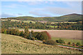
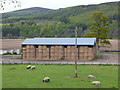
Haugh of Dandaleith
A haugh is flat land beside a river, originally a water meadow. The River Spey meanders along the far side of the haugh. This land does become waterlogged in exceptionally wet weather. The hill on the skyline at right is Ben Aigen (471 metres).
Image: © Anne Burgess
Taken: 9 Oct 2012
0.25 miles