IMAGES TAKEN NEAR TO
Craigellachie, ABERLOUR, AB38 9RJ
Introduction
This page details the photographs taken nearby to AB38 9RJ by members of the Geograph project.
The Geograph project started in 2005 with the aim of publishing, organising and preserving representative images for every square kilometre of Great Britain, Ireland and the Isle of Man.

There are currently over 7.5m images from over14,400 individuals and you can help contribute to the project by visiting https://www.geograph.org.uk
Image Map
Images are licensed for reuse under creativecommons.org/licenses/by-sa/2.0
Notes
- Clicking on the map will re-center to the selected point.
- The higher the marker number, the further away the image location is from the centre of the postcode.
Image Listing (5 Images Found)
Images are licensed for reuse under creativecommons.org/licenses/by-sa/2.0
Image
Details
Distance
1
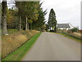
Minor road approaching Windyhillocks
Looking north-eastward.
Image: © Peter Wood
Taken: 25 Oct 2018
0.02 miles
2
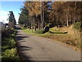
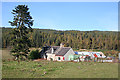
Windyhillocks
This is a fudge, really, because Windyhillocks proper is hidden by the new house at upper right.
Image: © Anne Burgess
Taken: 10 Oct 2012
0.02 miles
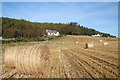
4
Dowalls farm on the right: Blue Hill in the distance to left.
Image: © Des Colhoun
Taken: 6 Aug 2006
0.23 miles
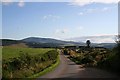
5
Dowalls Croft
The house here is almost surrounded by sheds, barns, vans, and other forms of storage, but it still enjoys a south-westerly view and plenty of sunshine.
Image: © Anne Burgess
Taken: 10 Oct 2012
0.24 miles