IMAGES TAKEN NEAR TO
Craigellachie, ABERLOUR, AB38 9RD
Introduction
This page details the photographs taken nearby to AB38 9RD by members of the Geograph project.
The Geograph project started in 2005 with the aim of publishing, organising and preserving representative images for every square kilometre of Great Britain, Ireland and the Isle of Man.

There are currently over 7.5m images from over14,400 individuals and you can help contribute to the project by visiting https://www.geograph.org.uk
Image Map
Images are licensed for reuse under creativecommons.org/licenses/by-sa/2.0
Notes
- Clicking on the map will re-center to the selected point.
- The higher the marker number, the further away the image location is from the centre of the postcode.
Image Listing (5 Images Found)
Images are licensed for reuse under creativecommons.org/licenses/by-sa/2.0
Image
Details
Distance
1
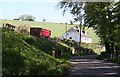
Kininvie Cottages
Farm cottages by the public road at Kininvie Home Farm.
Image: © Anne Burgess
Taken: 3 May 2007
0.00 miles
2
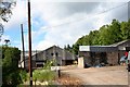
Kininvie Farm Entrance
The farm of Kininvie on the road to Maggieknockater.
Image: © Andrew Wood
Taken: 18 Jun 2009
0.01 miles
3
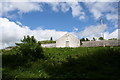
Kininvie Steading
A view from the roadside below of Kininvie steading.
Image: © Andrew Wood
Taken: 18 Jun 2009
0.06 miles
4
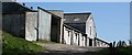
Kininvie Farm
The steading looks as if it has been added to or modernised at some point, because it is not traditional in style.
Image: © Anne Burgess
Taken: 3 May 2007
0.06 miles
5
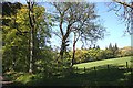
Woodland
The whole of the road past Kininvie is shaded by mature broadleaved trees, as are the field boundaries where they coincide with the course of a burn, as here.
Image: © Anne Burgess
Taken: 3 May 2007
0.21 miles