IMAGES TAKEN NEAR TO
ABERLOUR, AB38 9LT
Introduction
This page details the photographs taken nearby to AB38 9LT by members of the Geograph project.
The Geograph project started in 2005 with the aim of publishing, organising and preserving representative images for every square kilometre of Great Britain, Ireland and the Isle of Man.

There are currently over 7.5m images from over14,400 individuals and you can help contribute to the project by visiting https://www.geograph.org.uk
Image Map
Images are licensed for reuse under creativecommons.org/licenses/by-sa/2.0
Notes
- Clicking on the map will re-center to the selected point.
- The higher the marker number, the further away the image location is from the centre of the postcode.
Image Listing (11 Images Found)
Images are licensed for reuse under creativecommons.org/licenses/by-sa/2.0
Image
Details
Distance
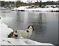
1
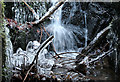
Winter treasure trove found on Christmas Day 2006
Hidden under the culvert on a sub zero Christmas morning a myriad of action and colour.
Image: © Des Colhoun
Taken: 25 Dec 2006
0.16 miles
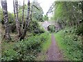
2
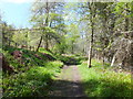
The Speyside Way
A long distance footpath and cycle track, here following the line of the former Speyside Railway.
Image: © Alpin Stewart
Taken: 16 May 2015
0.19 miles
3
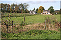
Cottages at Kinermony
These cottages stand one on either side of the minor road that joins the A95 at Kinermony.
Image: © Anne Burgess
Taken: 29 Sep 2014
0.19 miles
5
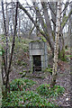
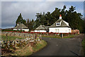
Orphaned Fireplace
I surmise that this is the fireplace and chimney of a railwaymen's wooden hut that has long since vanished.
Image: © Anne Burgess
Taken: 18 Jan 2022
0.20 miles
7
Strathspey Railway trackbed
Passing Kinnermony. A track to the Spey crosses the bridge.
Image: © Richard Webb
Taken: 4 Aug 2014
0.22 miles
8
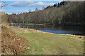
Looking upstream on the Kinermony Beat of the River Spey.
One of the most beautiful salmon beats on the fabled River Spey taken in March.
Image: © Des Colhoun
Taken: 8 Mar 2006
0.24 miles
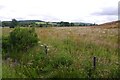
9
Between Pool Shuan and Upper Craig
The map shows Pool Shuan upstream, and Upper Craig is a little downstream.
Image: © Anne Burgess
Taken: 20 Mar 2018
0.24 miles
10
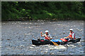
Canoeing on the River Spey
A two-man crew getting close to some gentle white water on the four-day trip from Aviemore to Spey Bay.
Image: © Anne Burgess
Taken: 20 Jun 2022
0.24 miles