IMAGES TAKEN NEAR TO
Rothes, ABERLOUR, AB38 7AQ
Introduction
This page details the photographs taken nearby to AB38 7AQ by members of the Geograph project.
The Geograph project started in 2005 with the aim of publishing, organising and preserving representative images for every square kilometre of Great Britain, Ireland and the Isle of Man.

There are currently over 7.5m images from over14,400 individuals and you can help contribute to the project by visiting https://www.geograph.org.uk
Image Map
Images are licensed for reuse under creativecommons.org/licenses/by-sa/2.0
Notes
- Clicking on the map will re-center to the selected point.
- The higher the marker number, the further away the image location is from the centre of the postcode.
Image Listing (6 Images Found)
Images are licensed for reuse under creativecommons.org/licenses/by-sa/2.0
Image
Details
Distance
1
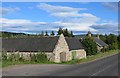
Steading, Pitcraigie Cottage
Beside the A941, Glen of Rothes.
Image: © Richard Webb
Taken: 4 Aug 2014
0.02 miles
2
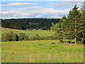
Glen of Rothes
Cattle have replaced barley in this part of the glen.
Image: © Richard Webb
Taken: 4 Aug 2014
0.02 miles
3
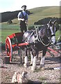
Little Haugh Agricultural Museum
This life-size model used to stand outside the museum, right beside the A941.When the lease expired the museum moved to Ladycroft, near Archiestown. It could be disconcerting on a dark wet night to see the model looming in the headlights!
Image: © Anne Burgess
Taken: 16 Jul 1983
0.09 miles
4
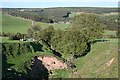
Caochan Stripe
Looking down the burn towards Little Haugh, just visible beyond the cattle. In the distance are Glen of Rothes House, with Sauchenbush above on the hill.
Image: © Anne Burgess
Taken: 6 May 2007
0.10 miles
5
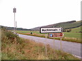
Road condition monitoring station. Glen of Rothes
Apart from being the turn off to the fishery, (just visible in the background) this is the spot where the conditions on the road are monitored for winter gritting. The electrical components are powered by solar panel. (top left)
Image: © alan souter
Taken: 27 Sep 2006
0.12 miles
6
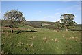
Pitcraigie
Looking across the fields above Pitcraigie. In the distance are Auchenroath, with Sauchenbush above, in Image
Image: © Anne Burgess
Taken: 6 May 2007
0.24 miles