IMAGES TAKEN NEAR TO
Auchnarrow, BALLINDALLOCH, AB37 9JP
Introduction
This page details the photographs taken nearby to AB37 9JP by members of the Geograph project.
The Geograph project started in 2005 with the aim of publishing, organising and preserving representative images for every square kilometre of Great Britain, Ireland and the Isle of Man.

There are currently over 7.5m images from over14,400 individuals and you can help contribute to the project by visiting https://www.geograph.org.uk
Image Map
Images are licensed for reuse under creativecommons.org/licenses/by-sa/2.0
Notes
- Clicking on the map will re-center to the selected point.
- The higher the marker number, the further away the image location is from the centre of the postcode.
Image Listing (15 Images Found)
Images are licensed for reuse under creativecommons.org/licenses/by-sa/2.0
Image
Details
Distance
1
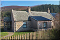
The Kirkie
This cottage was originally built as a kirk for the Protestant people of the immediate area. It is marked on the 19th century maps as a chapel of ease, that is, an extra kirk provided for parishioners living a long way from the main parish kirk. It is now a private house.
Image: © Anne Burgess
Taken: 21 Mar 2022
0.00 miles
2
The Kirkie
This cottage was originally built as a kirk for the Protestant people of the immediate area. It is marked on the 19th century maps as a chapel of ease, that is, an extra kirk provided for parishioners living a long way from the main parish kirk. It is now a private house.
Image: © Anne Burgess
Taken: 21 Mar 2022
0.01 miles
3
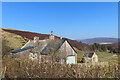
Minor road to Braes of Glenlivet
Crossing Culraggie Bridge. The forested hill is The Bochel.
Image: © Alan Reid
Taken: 26 Aug 2024
0.04 miles
4
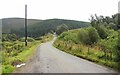
Track to Refreish
Refreish is out of sight round the corner. On the right is the steep northern slope of The Bochel.
Image: © Anne Burgess
Taken: 21 Mar 2022
0.05 miles
5
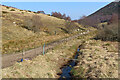
Culraggie Burn
Looking downstream from Culraggie Bridge. The road on the left is the next part of the waymarked Bochel circuit walk.
Image: © Anne Burgess
Taken: 21 Mar 2022
0.05 miles
6
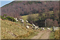
Sheep at Refreish
These are Blackface sheep, brought to the lower ground for the winter and lambing. In the background is The Bochel.
Image: © Anne Burgess
Taken: 21 Mar 2022
0.07 miles
7
Glen of Crombie Water
Looking down the glen of Crombie Water, with The Bochel on the right, Carn na h-Iolaire on the left, Carn Tullich in the distance and Cairn Muldonich beyond.
Image: © Antony Dixon
Taken: 2 Jul 2018
0.10 miles
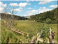
9
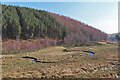
Meanders
The Crombie Water meanders across the flat floor of a glacial channel after being constrained through a narrow glen west of The Bochel.
Image: © Anne Burgess
Taken: 21 Mar 2022
0.14 miles
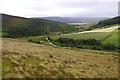
10
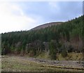
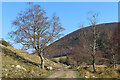
The Bochel
A steep wee hill, The Bochel is seen here from the west, rising above the Crombie Water
Image: © Richard Webb
Taken: 15 Jan 2005
0.14 miles